





A Landmark Climate Study
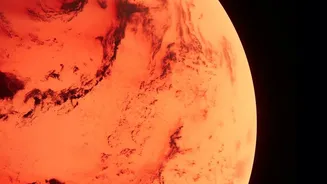
Researchers from the Physical Research Laboratory (PRL) in Ahmedabad have unveiled a detailed map of the Martian climate system. Published in the journal Current Science, their work provides fresh insights into how temperatures fluctuate and circulate
across the Red Planet. Focusing on two massive impact basins, Hellas and Argyre, the team analyzed how the planet's topography and eccentric orbit create some of the most extreme weather in the solar system. This isn't just a weather report; it's a crucial piece of the puzzle in understanding how Mars evolved from a potentially warmer, wetter world into the cold desert we see today. The findings are a testament to India's growing leadership in planetary science.
Decoding the Temperature Extremes
The headline's range of 150K to 295K highlights the incredible temperature differences on Mars. For context, 150 Kelvin is a bone-chilling -123°C, while 295K is a relatively mild 22°C. Some regions can even reach 27°C in the summer. These massive swings are largely due to Mars's incredibly thin atmosphere, which is about 100 times less dense than Earth's. Without a thick atmospheric blanket to trap and distribute heat, the Martian surface heats up rapidly in sunlight and loses that heat just as quickly when the sun sets. The planet's wonky, elliptical orbit also plays a major role. Mars gets significantly closer to the sun during its southern hemisphere's summer, making that season particularly intense.
So, What Are Zonal Waves?
Beyond simple temperature readings, the scientists mapped large-scale patterns of thermal energy moving across the planet, known as zonal waves. Think of them as massive, planet-wide ripples in the atmosphere, similar to jet streams on Earth. These waves are an indirect window into Mars's atmospheric circulation. The study found a striking difference between the two basins they studied. The Argyre basin was dominated by a single, large wave pattern (called wave-1). In contrast, the deeper and larger Hellas basin showed more complex and fragmented wave-2 and wave-3 patterns that changed with the seasons. This shows that the planet's geography—its craters, canyons, and plains—plays a profound role in shaping its weather systems.
The Tools Behind the Discovery
This groundbreaking research was made possible through a collaborative, international approach. The PRL scientists analyzed high-precision data from the Emirates Mars Infrared Spectrometer (EMIRS). This instrument is flying aboard the United Arab Emirates' Hope spacecraft, which has been orbiting Mars since 2021. This effort builds on a long legacy of Indian contributions to Mars exploration, most notably through the nation's own Mars Orbiter Mission (Mangalyaan), which operated from 2014 to 2022. Instruments on Mangalyaan, like the Thermal Infrared Imaging Spectrometer (TIS), helped lay the groundwork for understanding Martian surface temperatures and atmospheric processes.
Why This Research Matters
Mapping Mars's climate isn't just an academic exercise; it has critical practical applications. A precise understanding of atmospheric dynamics, temperature swings, and weather patterns is essential for planning future robotic and human missions. Knowing how and when major dust storms might arise, or how temperatures will affect equipment, is vital for mission safety and success. Furthermore, this study helps refine our climate models. The PRL team found that current models were often about 10 Kelvin too cool in their temperature predictions compared to the real-world data from space. Closing this gap between theory and observation is a vital step toward accurately predicting Martian weather and understanding its long-term climate evolution.