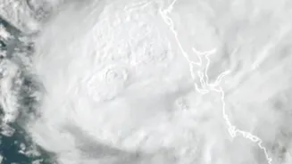








What is Cyclone Akvan?
Cyclone Akvan is the latest tropical cyclone to form in the Bay of Bengal. The storm originated from a low-pressure area that developed around November 13 and steadily gained strength over the warm sea waters. On November 16, the India Meteorological
Department (IMD) officially classified it as a cyclonic storm, assigning it the name Akvan, which was proposed by Iran. By November 18, the system had intensified into a Severe Cyclonic Storm. As of the latest updates, Akvan is located over the west-central Bay of Bengal, several hundred kilometres off the coast of Andhra Pradesh and Tamil Nadu. The storm has been moving slowly, which sometimes allows a cyclone to gather more strength and moisture from the ocean.
Projected Path and Landfall
Forecasting the exact path and intensity of a cyclone can be challenging, as different weather models sometimes offer conflicting predictions. However, the IMD's latest forecast on November 18 projects that Severe Cyclonic Storm Akvan will move in a north-northwestward direction. It is expected to make landfall on November 20, with the likely crossing point somewhere between Narsapur in Andhra Pradesh and Puri in Odisha. While there was earlier speculation that it could become a 'very severe cyclonic storm', the IMD has since revised its forecast, now expecting it to cross the coast as a 'severe cyclonic storm' with maximum sustained wind speeds of 90-100 kmph, gusting up to 110 kmph.
Which Areas Are on High Alert?
The primary areas of concern are the coastal districts of Andhra Pradesh and Odisha. The IMD has issued a 'Red Message' warning for these states, indicating the likelihood of heavy to extremely heavy rainfall on November 19 and 20. Specifically, the stretch of coast from North Andhra Pradesh through Yanam and up to South Odisha is on high alert for strong winds, torrential rain, and dangerous sea conditions. Coastal communities in these regions can expect significant disruptions, including potential flooding and damage to infrastructure. Fishermen have been strictly advised not to venture into the Bay of Bengal. Neighbouring states like Tamil Nadu, Puducherry, and West Bengal are also expected to experience rainfall and rough seas.
How Authorities Are Preparing
State and national disaster response agencies are on high alert and have begun precautionary measures. The National Disaster Response Force (NDRF) and State Disaster Response Force (SDRF) have pre-positioned teams in vulnerable coastal districts of both Andhra Pradesh and Odisha. The Andhra Pradesh government has set up emergency contact numbers and is preparing for potential evacuations from low-lying areas. In Odisha, the government has already restricted tourism activities along the coast as a precautionary measure. Local authorities are focused on moving people from hutments and other vulnerable structures to safer shelters and ensuring that essential services are prepared for the storm's impact. The IMD is issuing frequent bulletins to keep both the public and government agencies updated on the storm's progress.
A Rare Occurrence for the Season
The development of Akvan is notable as it follows a relatively subdued period for cyclonic activity in the region. The storm is reportedly the third to threaten the Andhra Pradesh coast within a month, an event described by an IMD official as a 'very rare'. Its formation breaks the quiet spell of the post-monsoon season and serves as a critical reminder of the region's vulnerability to severe weather systems that can form rapidly in the Bay of Bengal. The storm's unpredictable behaviour, including its slow initial movement and shifts in the forecast track, highlights the complexities involved in cyclone prediction and the importance of heeding official warnings.