





A Planetary Cold Case
For decades, the central mystery of Mars has been where all the water went. We see the scars of ancient rivers and the basins of long-dead lakes, but the Red Planet today is a frigid, arid desert. The big questions have always been: When did this change
happen, and how long did it take? Was it a sudden cataclysm or a slow, grinding decline? Answering this is key to understanding if Mars ever had the right conditions for life. After more than a decade of roving across Gale Crater, NASA's Curiosity rover is providing the most detailed timeline yet for this planetary transformation.
Reading the Rocks Like a Book
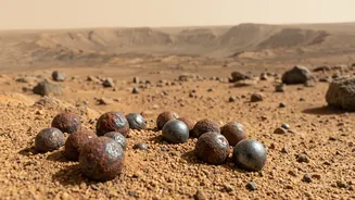
The key to this discovery lies in reading the rock layers of Mount Sharp, the 5-kilometer-tall mountain inside Gale Crater that Curiosity has been climbing since 2014. Each layer of rock is a chapter in Mars's history, with the oldest at the bottom and the youngest at the top. By drilling into these layers and analyzing their composition, scientists can piece together the environmental conditions at the time they formed. A new study highlights how a common rust-colored mineral, hematite, is acting as a crucial historical marker. The size of the tiny crystals that make up the hematite reveals how long water was present and how warm it was.
The New Martian Calendar
Using its on-board laboratory called CheMin, Curiosity analyzed 20 rock samples from different elevations. The results paint a detailed, and surprisingly prolonged, picture of the end of Mars's wet era. In the lower, older layers of the crater, hematite crystals were found to be much larger—some reaching 65 nanometers. This indicates they were bathed in warm groundwater for extended periods. The study suggests these warm, wet conditions in the buried rocks could have persisted for up to 4.7 million years, even as the surface climate was already getting colder. In the higher, younger rock layers, the hematite crystals were much smaller, suggesting water was less abundant and not sticking around for long. This gradual shift, rather than a single event, defines the timeline of Mars's great drying.
From Persistent Lakes to Drying Ponds
The rover's journey up Mount Sharp has physically traced this transition. The mission began by exploring what were once persistent freshwater lakebeds, full of clay minerals formed in water. As it climbed, Curiosity entered a 'transition zone' rich with salty minerals called sulfates. These sulfates and the new hematite data suggest the final stages were not a clean break, but a series of fits and starts. The era of deep, stable lakes gave way to one of shallow, briny ponds and streams that would periodically appear and then evaporate, leaving the tell-tale mineral salts behind. This episodic wetting and drying happened over millions of years as Mars slowly lost its atmosphere and became the desert planet we see today.
Why This Timeline Matters
Establishing this timeline does more than just solve a planetary puzzle. It fundamentally refines our search for signs of past life. By showing that pockets of warm, liquid water may have existed underground for millions of years longer than previously thought, it expands the window of time when Mars could have been habitable. While the surface grew colder and was bombarded by radiation, these subsurface aquifers could have remained potential havens for any microbial life that might have existed. This new, detailed climate record helps scientists better understand how planets can lose their habitability, providing invaluable context for understanding planetary evolution across the galaxy—including our own.