








A Region on High Alert
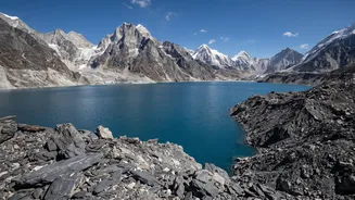
The Indian Himalayan Region is facing a surge in climate-induced disasters. The primary threats are Glacial Lake Outburst Floods (GLOFs), landslides, and flash floods. As global temperatures rise, glaciers are melting at an unprecedented rate, creating
thousands of new and expanding glacial lakes. Many of these are unstable, held back only by loose walls of rock and debris. The failure of such a natural dam, as seen in the 2023 Sikkim disaster, can release a devastating torrent of water, ice, and rock downstream, destroying lives, homes, and critical infrastructure like hydropower dams. Studies show the Himalayas are warming faster than the global average, making these events more frequent and intense. According to one UN-led study, India has recorded the highest number of deaths from GLOFs in the Hindu Kush Himalaya region, highlighting the extreme vulnerability of its mountain communities.
The Gaps in the Safety Net
Recent scientific assessments have delivered a stark warning: monitoring and early warning systems across the Himalayas are dangerously inadequate. A study published in early 2026 revealed that the risks are poorly assessed and weakly monitored, leaving nearly a million downstream residents facing potential flood threats. Even when monitoring equipment is in place, significant gaps remain. For instance, a detailed study in Bhutan found that out of 278 glacial lakes assessed, only 51 were covered by the existing monitoring network, leaving several newly identified high-hazard lakes unwatched. The problem is not just a lack of sensors. Existing systems are often designed for specific, predictable hazards like seasonal floods, but are unprepared for complex, cascading events like the massive ice-rock avalanche on the Nepal-China border in August 2026. That disaster unfolded so rapidly that conventional systems offered no meaningful warning.
The Challenge of the Last Mile
Implementing effective early warning in the Himalayas is a monumental challenge. The geographical complexity, with its rugged terrain and vast, remote areas, makes uniform monitoring incredibly difficult. Many high-risk valleys lack reliable mobile or satellite connectivity, which is essential for transmitting real-time data from sensors to authorities and then to the public. This is often called the 'last mile' problem: ensuring a warning actually reaches the people at risk in a timely and understandable way. Experts also point to a lack of low-cost, durable, and locally maintainable technology. Furthermore, there are institutional gaps, with weak coordination between scientific bodies, disaster management agencies, and local governments. For a warning to be effective, it requires more than just a siren; it needs a community that is trained and prepared to respond to the alert.
Building a Modern, Integrated System
The consensus among experts is that a multi-layered, technologically advanced approach is needed. Recommendations call for a 'space-air-ground' monitoring network. This would involve wide-area satellite scanning to identify potential trouble spots, followed by targeted high_resolution monitoring with drones and ground sensors. Integrating technologies like radar, automatic weather stations, and AI_driven models can provide more accurate and timely warnings. However, technology alone is not enough. Studies emphasize a bottom_up, community_led approach where local populations are trained to maintain and operate systems and are involved in creating disaster response plans. This builds resilience from the ground up, empowering the first responders in any crisis.
A Call for Cross_Border Cooperation
Disasters do not respect political boundaries, and many Himalayan glaciers and rivers are shared between India, China, Nepal, and Bhutan. A GLOF originating in one country can have catastrophic consequences downstream in another. This makes trans_boundary cooperation essential for effective disaster risk reduction. Experts have repeatedly called for a regional platform, such as a Himalayan Monitoring Centre, to facilitate the sharing of real_time data, conduct joint research, and coordinate warnings. While some bilateral agreements exist, they are often limited and do not cover the complex, cascading hazards now being seen. Establishing formal, rapid notification channels between Himalayan nations is considered a critical step to extend warning times and save lives across the entire region.