


The Paradox of a Wet Winter
It seems counterintuitive, but the seeds of a destructive summer fire season are often sown in a wet winter and spring. Unusually high rainfall, like that seen in parts of Spain earlier in the year, encourages a burst of vegetation growth. Grasses, shrubs,
and forest undergrowth flourish, creating a landscape that appears lush and green. This abundance of plant life, however, is a ticking time bomb. When the seasons change and the rains stop, this explosion of new growth provides an enormous amount of potential fuel for fires. This phenomenon, sometimes called "weather whiplash," is an increasingly critical driver of wildfire risk in Western Europe as climate change disrupts traditional weather patterns.
A Summer of Extreme Drought and Heat
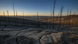
Following the wet winter, recent months have seen severe drought and a series of record-breaking heatwaves across the continent. This intense, prolonged heat acts as a giant kiln, sucking the moisture out of the abundant vegetation grown during the wetter months. This process transforms sprawling fields and forests into what firefighters call "tinderbox conditions"—vast areas of bone-dry, highly flammable fuel. The summer of 2026 is already considered the hottest on record in Spain, and this combination of high fuel loads from the winter and extreme summer drying has created the perfect recipe for explosive, fast-moving fires.
The Menace of the Ember Storm
A major factor complicating firefighting efforts is the phenomenon of the "ember storm." Wildfires don't just spread along a continuous flame front; they launch millions of tiny, burning fragments—embers or firebrands—into the air. Carried by strong winds, these embers can travel for kilometres, flying over natural barriers like rivers and man-made firebreaks like roads. This process, known as "spotting," allows a fire to leapfrog across the landscape, starting new blazes far ahead of the main fire. Homes and entire neighbourhoods can find themselves under attack from a shower of embers, igniting structures even when the primary fire seems distant, making containment incredibly unpredictable and dangerous.
When Fire Creates Its Own Weather
The most intense wildfires become so powerful that they generate their own weather systems. The immense heat from the fire causes air to rise rapidly in a powerful updraft, carrying smoke, ash, and moisture high into the atmosphere. As this plume rises and cools, the moisture condenses to form a towering, turbulent cloud called a pyrocumulus or, in extreme cases, a pyrocumulonimbus. These fire-generated thunderstorms can produce their own lightning, which can strike the dry ground miles away and ignite new fires without warning. They also create powerful, erratic downbursts of wind that can suddenly change a fire's direction and speed, posing a grave threat to firefighters on the ground. One of the fires in France's Gironde region this year generated just such a cloud, exacerbating the speed of its spread.