






What Is Earth Observation, and Why Now?
Earth Observation (EO) is the gathering of information about our planet's physical, chemical, and biological systems via remote-sensing technologies, primarily satellites. For decades, this was the domain of large government space agencies. Today, the field
is experiencing explosive growth, driven by a shift from government-led programs to a vibrant private sector. The market for EO is projected to grow significantly, with some analysts predicting it will expand from just over USD 2 billion in 2026 to nearly USD 7 billion by 2034. This boom is fueled by satellite miniaturization, lower launch costs, and a surge in commercial demand for geospatial data. Private companies are now deploying entire constellations of smaller, cheaper satellites, fundamentally changing the landscape.
India's Leap into the Private Space
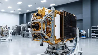
India is rapidly becoming a key player in this commercial space boom. Since opening the sector to private participation in 2020, the country has seen its space startup ecosystem flourish. A landmark public-private partnership (PPP) agreement was signed between India's space regulator, IN-SPACe, and a consortium led by Bengaluru-based startup Pixxel. This partnership aims to build and operate India's first privately-led national EO satellite constellation. The consortium plans to invest over ₹1,200 crore to deploy 12 advanced satellites by 2030, which will be designed, built, owned, and operated by Indian private companies. This move signals a major shift, intended to enhance India's observational capabilities and create a self-reliant EO ecosystem.
How AI Supercharges Satellite Data
The sheer volume of data beamed down from these satellite constellations is staggering. Making sense of it all would be impossible for human analysts alone. This is where artificial intelligence (AI) becomes indispensable. AI and machine learning algorithms can sift through petabytes of satellite imagery at incredible speeds, detecting patterns, changes, and features that would be invisible to the human eye. This automated analysis transforms raw data into actionable intelligence, used for everything from predicting crop yields and monitoring deforestation to tracking urban development and assessing damage after natural disasters.
The Tangible Benefits on the Ground
The applications of AI-powered EO are vast and transformative. In agriculture, it enables 'precision farming,' where satellite data helps farmers monitor crop health, optimise irrigation, and manage resources, boosting yields and promoting sustainability. During natural disasters like floods or wildfires, satellite analytics provide rapid situational awareness, helping emergency services map affected areas and coordinate response efforts. It's also a crucial tool for urban planning, monitoring infrastructure, tracking illegal mining or logging, and fighting climate change by providing clear data on environmental shifts.
An Unregulated Frontier in the Sky
This technological leap also brings significant challenges and governance questions. A key issue is the dual-use nature of the data; imagery used for humanitarian aid can also be used for military targeting. This raises national security concerns and questions about who controls the flow of information, especially during conflicts. Privacy is another major concern, as increasingly high-resolution imagery raises questions about the 'reasonable expectation of privacy'. Furthermore, the proliferation of thousands of satellites in Low Earth Orbit (LEO) is creating a massive space debris problem. Experts warn of an increased risk of collisions, which could generate even more debris and potentially trigger a chain reaction known as the 'Kessler Syndrome,' rendering some orbits unusable.