






A Cascade of Colour-Coded Warnings
In the days leading up to the recent deluge, the India Meteorological Department (IMD) and the Kerala State Disaster Management Authority (KSDMA) issued a series of alerts. Initially, many districts were placed under an Orange Alert, signalling authorities
to be prepared for heavy to very heavy rainfall. However, as the weather system intensified, these were rapidly upgraded. By Saturday, August 1, a Red Alert—the highest level of warning, indicating a need for immediate action—was in effect for nine districts, including Pathanamthitta, Idukki, and Kottayam, which would become some of the worst-hit areas. In subsequent days, more districts were added to the Red Alert list as the state received nearly three times its normal rainfall for the period. This system, which also includes Yellow Alerts to 'be updated', is the standard protocol for communicating weather threats.
The Reality on the Ground
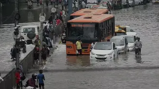
Despite the alerts, the reality in many parts of Kerala was overwhelming. The state witnessed widespread flooding, with some areas in Kottayam and Pathanamthitta experiencing inundation worse than the devastating 2018 floods. Intense rainfall over short periods led to flash floods and numerous landslides. For instance, some areas recorded rainfall that clearly met the criteria for a Red Alert even before the official declaration was upgraded from Orange. This lag has raised questions about whether the warnings, though issued, fully captured the imminent severity and specific locations of the downpour. Critics argue that the flood risk was underestimated, leaving residents with less time to react as rivers like the Pamba and Manimala swelled and homes were submerged.
The Challenge of Pinpoint Forecasting
Forecasting extreme weather in a region with topography as complex as Kerala's is a significant scientific challenge. The Western Ghats can cause highly localised, intense rainfall events—often called cloudbursts or deep mesoscale convective systems—that are difficult to predict with precise timing and location. Even advanced weather models can struggle to forecast the exact intensity of these events. Officials from KSDMA have defended the process, stating that forecasts are revised frequently based on the latest data and that it's standard practice to upgrade alerts as a weather system evolves. However, this inherent unpredictability means a gap can exist between a district-wide alert and the specific, life-threatening reality faced by a village in a landslide-prone hilly area.
From Alert to Action
Issuing a warning is only one part of the equation; ensuring it is received, understood, and acted upon is another. Kerala has invested in its communication systems, including the 'SACHET' platform, which can send loud, overriding emergency alerts to mobile phones in targeted areas, even if they are on silent mode. Yet, authorities stress that residents shouldn't rely solely on alerts for their safety preparations. The state government has also faced criticism, with some officials stating their role is to disseminate the IMD's warnings, effectively placing responsibility for forecast accuracy with the central agency. Experts argue that beyond alerts, Kerala needs a more robust long-term disaster mitigation strategy, as you cannot evacuate an entire population based on rainfall warnings alone.