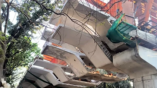


Bengaluru’s Ejipura flyover is now expected to be completed by mid-2026.
The flyover project in Bengaluru, which started way back in 2017, has been delayed repeatedly, with multiple contractors, work stoppages and revised timelines, making it the butt of jokes and frustration of motorists.
The Ejipura flyover project
The Ejipura flyover is an elevated road corridor (2.3-2.5 km long) being built in south Bengaluru to ease traffic between Inner Ring Road or 100-Feet Road and Koramangala or Hosur Road. It includes ramps around Koramangala Kendriya Sadan and other busy junctions.
Ejipura flyover: Progress report
After years of delays and intermittent halts, work has regained pace in recent months, with significant portions of the structure now installed and ongoing ramp and segment work. A joint land acquisition
process is underway for remaining parcels needed for completion.
Welcome to Silicon valley of India, namma Bengaluru where Flyovers have X accounts to post their updates 😄👍@anil_lulla @ChristinMP_ @WF_Watcher @bengalurupost1 @naveenmzs https://t.co/6E5eTIYUU1
— VP (@v_two_p) July 18, 2025
Ejipura flyover jokes on social media
Netizens jokingly refer to the unfinished flyover as a “historic monument” or “heritage site” on Google Maps and in memes. It has been become such an important part of the popular culture that it has its own X handle too.
“Ejipura Flyover — Bengaluru’s newest heritage landmark. Opened: never,” wrote one user on X.
Another X user described resumption of work as a “historic day”, joking that the flyover looked like something built by ancestors or featured on MythBusters as an alien project.
An X user wrote, “No joke I moved to Koramangala pregnant and my son is now almost 8 and they’ve been building the flyover since before he was born to now when he’s in 2nd standard.”
“Ejipura Flyover: Started in 2017, now 70% done… in 2025! We’ve aged, our kids have graduated, and Bengaluru’s traffic invented time travel under its pillars. Deadline? June 2026. Who’s betting on 2030? Koramangala peeps, RT if you’ve lost years idling here!” another user wrote.
“You are missing a larger objective. Authorities want it to be added to wonders of the world list with an achievement. A Flyover that people could never fly over….” t’ll be a marvel that’ll convert Ejipura and Koramangala into a tourist destination for global tourists,” said another X user.
Ejipura Flyover has finally resumed construction. A historical day not just for Bangalore but also for us who have grown up with this historical monument.
Our forefathers started work on this centuries ago despite the odds. Our ancestors played hide and seek along its beautiful…
— Varun Agarwal (@varun067) October 13, 2025
Why motorists need Ejipura flyover
Once completed, the flyover is expected to:
- Reduce congestion on 100-Feet Road and Koramangala stretch
- Improve connectivity from Inner Ring Road to Hosur Road or National Highway
- Help ease daily traffic bottlenecks for commuters in south Bengaluru.
Ejipura flyover: The route
The planned Ejipura Flyover (often called the Koramangala–Ejipura Elevated Corridor) is a long elevated road (about 2.38 – 2.5 km) that connects key junctions in south Bengaluru:
It starts at:
Ejipura Main Road or Inner Ring Road (IRR) junction: A busy signal point on Bengaluru’s Inner Ring Road that connects Koramangala, Indiranagar, and Domlur traffic.
The flyover rises from Inner Ring Road at Ejipura and travels southeast above Koramangala’s 100-Feet Road corridor — one of the city’s most congested roads.
It bypasses several busy junctions, including Sony World Junction and Kendriya Sadan traffic signal on Koramangala’s IRR or Hosur Road mix.
It connects to Hosur Road (National Highway) near the Kendriya Sadan / Koramangala Water Tank junction, feeding traffic toward major city routes and suburbs. Entry and exit ramps are planned near St John’s Hospital and other key points to help distribute traffic.
How the flyover will boost Bengaluru’s road network
Inner Ring Road (IRR): IRR is a major east–west arterial road connecting Indiranagar to Koramangala and Madiwala. The flyover begins here at Ejipura, keeping traffic flowing without stopping at signals.
100-Feet Road (Koramangala): This is one of the busiest north–south corridors in south Bengaluru, bringing people toward Hosur Road, Sarjapur Road, and the city centre. The flyover runs above this stretch, removing traffic bottlenecks.
Hosur Road (NH-44): A major national highway that carries traffic between Bengaluru and industrial/commercial hubs to the south and southeast. The flyover’s endpoint feeds smoothly into this route.
How the flyover will help traffic
This project is designed to create a faster, signal-free corridor through one of Bengaluru’s most congested zones. Here’s how it helps:
It will go above at least seven signals or choke points such as Ejipura main signal, Sony World junction, and Kendriya Sadan signal — reducing stops and delays.
Once complete, commute time on this stretch (which currently gets heavily jammed) could reduce by 20-30 minutes during peak hours because vehicles won’t have to stop at traffic lights.
Koramangala to Hosur Road or Outer Bangalore: It will ensure smoother movement for commuters working in IT and business areas.
Inner Ring Road traffic can flow across without mixing with local left/right turning traffic at junctions.
Traffic from Sarjapur Road will move smoothly with ramps.
/images/ppid_59c68470-image-177070527012744285.webp)

/images/ppid_59c68470-image-177070509254577447.webp)
/images/ppid_59c68470-image-17707051657521865.webp)
/images/ppid_59c68470-image-177070523525947868.webp)
/images/ppid_59c68470-image-177070520508144474.webp)
/images/ppid_59c68470-image-177070512991253005.webp)
/images/ppid_59c68470-image-177070505765120255.webp)
/images/ppid_a911dc6a-image-177070523014039316.webp)