
/images/ppid_a911dc6a-image-177102646607765106.webp)


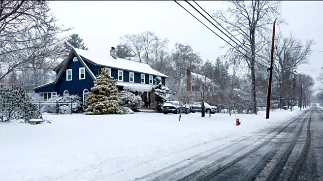
A powerful winter storm is sweeping across the United States, bringing subzero temperatures, heavy snow and widespread ice from Texas to New England.
More than 150 million people are under weather alerts as conditions intensify through the weekend, and the Northeast and Mid-Atlantic, home to some of the country’s most densely populated cities, are preparing for prolonged disruption.
Behind this extreme spell of cold lies a shift occurring far above ground level: a disturbance in the polar vortex, an atmospheric structure that helps regulate how far south Arctic air can travel.
The term has appeared frequently in American forecasts during severe winters, although the polar vortex itself is neither new nor a storm. It is a stable part of the atmosphere
that usually remains far removed from day-to-day weather. But when it weakens or expands, the effects can cascade downwards, influencing the jet stream and allowing Arctic air to spill into regions unaccustomed to such deep cold.
This interaction is shaping the storm now unfolding across the eastern United States.
What Is The Polar Vortex?
The polar vortex is a large mass of extremely cold, low-pressure air that circulates high above the Arctic. It exists because the far north remains significantly colder than the regions beneath it, creating a strong temperature contrast that produces powerful winds. These winds rotate around the pole and typically confine the coldest air to the Arctic itself.
A similar vortex exists over the Antarctic, although the northern one has a greater influence on North American weather. The vortex is present throughout the year, weak in summer and strong in winter, and it does not behave like a passing weather system. Its primary role is simply to hold frigid air in place.
The term was long used in meteorology, but its wider public use surged after a severe cold outbreak in January 2014, when the phenomenon entered popular vocabulary during an unusually harsh American winter.
Why The Vortex Becomes A Problem When It Weakens Or Expands
A stable vortex keeps its cold air well-contained. Difficulties begin when it weakens, stretches or shifts away from the pole. During such episodes, the structure of the vortex becomes distorted, and its cold air can move outward. This southward movement is often accompanied by a change in the jet stream, the fast-moving current that guides storms across the US. Instead of flowing smoothly west to east, the jet stream becomes more wavy. Its deeper dips create a pathway for Arctic air to travel far beyond its usual limits.
In some winters, the vortex may also expand, occupying a larger region of the upper atmosphere and pushing cold air into mid-latitude regions that are not built for deep freezes. That is what forecasters say is happening now.
The expansion is allowing Arctic air to spill across several states, intensifying the weather system forming beneath it. Some researchers suggest that rapid warming in the Arctic may be contributing to more erratic jet stream behaviour, although this remains an area of active scientific study.
How This Breakdown Is Shaping The Current Winter Storm
The storm affecting the US is emerging in tandem with the vortex’s disruption. As the jet stream bends southwards, it is funnelling cold Arctic air across a vast stretch of the country while low-pressure systems supply moisture. The combination is creating a chain of snow, ice and intense cold that extends across thousands of kilometres.
More than 177 million people are already experiencing winter impacts, and over 200 million are under cold weather advisories or warnings. Snow first appeared in parts of Texas and Oklahoma before moving northeastward, prompting emergency declarations across multiple states. The breadth of the system is striking: snow and ice may stretch across nearly 2,000 miles from Texas to New England.
Forecasts indicate that the coldest air, between 23 and 25 January, will settle over the central and northern US, including North Dakota, South Dakota, Montana, Wyoming, Minnesota, Wisconsin, Iowa, Nebraska and Michigan.
Heavy snow and freezing rain are expected across Kansas, Oklahoma, Missouri, Illinois, Texas, Arkansas, Tennessee, Kentucky, Virginia, Maryland, West Virginia, Pennsylvania, New Jersey and New York.
In Louisiana, Mississippi, Alabama and Georgia, the conditions could be particularly hazardous because these states rarely encounter prolonged subzero temperatures.
Some areas may remain below freezing for more than 24 hours. Such long-lasting cold raises the risk of power cuts, frozen roads and severe travel disruption, especially in regions ill-equipped for extreme winter weather.
How The Northeast And Mid-Atlantic Are Being Affected
The corridor from Washington, DC, through Philadelphia and New York to Boston is approaching its most consequential period of the storm. As Arctic air continues to sink south and moisture converges along the coast, snowfall is expected to intensify across the region.
New York City may receive four to eight inches of snow, while parts of the Hudson Valley and northwest New Jersey could approach a foot if a coastal system strengthens.
Temperatures are expected to remain well below freezing even after the precipitation stops, reducing the chance of rapid melting. This increases the risk of icy roads and longer recovery times.
Wider Disruptions From The Storm
The expanding cold has led to significant disruption beyond snowfall. Multiple states are warning of potential power outages as ice accumulates on transmission lines. Travel has already been severely affected. More than 1,800 flights have been cancelled, and delays are expected to grow as the storm progresses. The US Federal Aviation Administration has warned of possible airport closures from Texas to the Northeast as conditions deteriorate.
In many areas, even after the storm weakens, icy surfaces may linger for days because temperatures will remain far below freezing. Meteorologists note that this is typical of polar-vortex-linked events, where cold air remains entrenched long after snowfall tapers off.
The Polar Vortex Is Not Behind Every Winter Storm
Despite its influence, the polar vortex is not the cause of every cold day or winter storm. Daily weather still depends on localised systems, including surface lows, cold fronts and moisture patterns.
The vortex shapes the broader environment in which these smaller features operate, but it does not dictate their exact behaviour. Forecasters refer to the polar vortex only when large-scale atmospheric shifts are underway, as is the case now.
What Comes Next
Although disruptions to the vortex can be identified days or even weeks in advance, their exact effects at ground level become clearer only as individual storms develop. The snowfall totals, ice accumulation and duration of extreme cold in the Northeast and Mid-Atlantic will depend on how the coastal low evolves and how much Arctic air continues to feed into it.
What is clear is that the weakened and expanded vortex has created the atmospheric conditions enabling one of the season’s most widespread winter storms, affecting millions across an enormous stretch of the United States.
/images/ppid_a911dc6a-image-177103853218557950.webp)


/images/ppid_a911dc6a-image-17710364781122582.webp)
/images/ppid_a911dc6a-image-177103642565816962.webp)
/images/ppid_a911dc6a-image-177103504309993710.webp)
/images/ppid_a911dc6a-image-177103508492594205.webp)