


/images/ppid_59c68470-image-178892752778714521.webp)
The world could soon look very different on maps after the United Nations General Assembly (UNGA) backed a push for a more accurate picture of the size of the world’s continents.
The “Correct the Map” resolution, led by African Union member states and the Bahamas, was approved by an overwhelming 164 votes on Friday. Six countries abstained, while the United States was the only country to vote against the proposal.
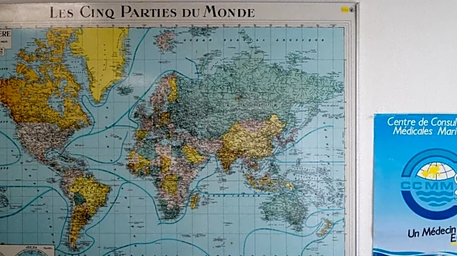
The move seeks to challenge the long-used Mercator projection, which can make countries and regions far from the Equator appear much larger than they really are.
Why The Current World Map Is Being Challenged?
The Mercator projection was created by European cartographer Gerardus Mercator in 1569. It remains widely used, particularly for navigation, because it helps show directions
accurately.
But it is less suitable for showing the true size of continents. As areas move further from the Equator, they appear increasingly enlarged.
Greenland is one of the clearest examples. On a Mercator map, the island can appear almost as large as Africa or even bigger than South America. In reality, Greenland is roughly the size of the Democratic Republic of Congo, while Africa is about 14 times larger than Greenland.
African countries behind the UN resolution argue that such distortions go beyond geography. They say they can create a misleading picture of the world’s regions and contribute to the “symbolic minimisation” of Africa in the public imagination.
The resolution also raises concerns that distorted maps can downplay the scale of development needs, infrastructure gaps and economic potential across Africa, Latin America and South Asia.
Africa Leads Push For A Fairer Map
The campaign gained momentum after the African Union adopted the Equal Earth map in March. Togo, representing the AU, then urged UN member states in April to consider adopting it. The UN held informal discussions on the proposal in July before Friday’s vote.
“Africa, once diminished on maps, now insists on being seen at its true scale – geographically, historically, morally, culturally, economically, diplomatically and globally,” Amma Twum-Amoah, commissioner for the AU’s Department of Health, Humanitarian Affairs and Social Development, said in March.
According to CNN, the UN resolution also calls on digital mapping platforms to work with member states and regional organisations to consider adopting more accurate map projections. Major online mapping services currently use versions of the Mercator projection.
The Equal Earth projection is designed to preserve the relative size of land areas more accurately. It also comes in different versions, including one that places Oceania at the centre rather than Greenwich in London.
(With inputs from CNN)



/images/ppid_59c68470-image-178892773475611531.webp)