

/images/ppid_a911dc6a-image-176987312843796402.webp)
/images/ppid_a911dc6a-image-176987305790383240.webp)
Dense fog, recurring cold waves, and persistent dryness defined the winter this January, as the month once again ended with a worrying rainfall and snowfall deficit, especially over the Himalayan states. Adding to the concerns, the weather department has predicted below-normal rain for February too, sounding the alarm over its impact on winter crops.
The India Meteorological Department (IMD) said the monthly deficit was nearly 31.5 per cent in January, with a significantly high shortfall in Jammu and Kashmir as well as Ladakh, where the mountain peaks remained snowless until mid-January. The monthly rainfall was the 11th lowest January rainfall since 2001.
The weather department has now raised an alarm with below-normal rains forecast in February
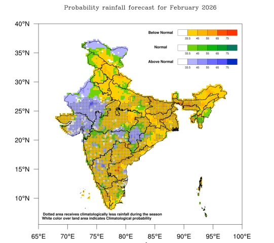
as well. According to IMD, the rainfall in February is likely to be less than 81% of the Long Period Average (LPA) with a significant shortfall over Northwest India, mainly Punjab, Haryana, Uttar Pradesh, Jammu and Kashmir.
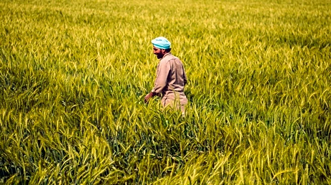
Less rain and snow, coupled with higher day and night temperatures in February, could impact winter crops, leading to lower yields. “We have issued agro-met advisories to farmers suggesting better irrigation for the standing crops. The dry weather and higher temperatures may lead to early maturing of crops like wheat and barley and early flowering in fruits and vegetables, which may cause lower yields this season,” said Director General of Meteorology (DGM) Dr Mrityunjay Mohapatra.
The weather department also warned that the increased heat stress could affect livestock as well, making them more susceptible to diseases. The forecast comes in the wake of increasing concerns over a rapidly warming climate, which has shortened the winter season over India.
According to IMD, a lesser number of western disturbances could be one of the reasons for the long dry spell. “Even though we didn’t experience any record-breaking temperatures, this January was definitely warmer than usual. The mean monthly temperatures were 0.28°C above normal for the country, with slightly higher day and night temperatures, especially over northeastern India,” said the IMD chief on Saturday.
The winters remained dry over North and Central India, including Delhi, until January 20, when two successive western disturbances hit the region, the first from January 21 to 24 and the second from January 26 to 28, bringing significant snowfall in the upper Himalayan regions like Jammu and Kashmir, Himachal Pradesh, and Uttarakhand.
Dense fog persisted for more days than usual, especially over the Indo-Gangetic plains. According to the weather data, foggy days lasted for around three weeks starting December 15, significantly impacting the visibility over the region.
There were also more cold wave days, lasting for over 9-13 days, especially over Himachal Pradesh and Jharkhand, while it was 3-6 days across most of North and parts of Central India and Rajasthan. Cold waves are experienced when the night temperatures drop at least 4.5-6.5°C below normal.
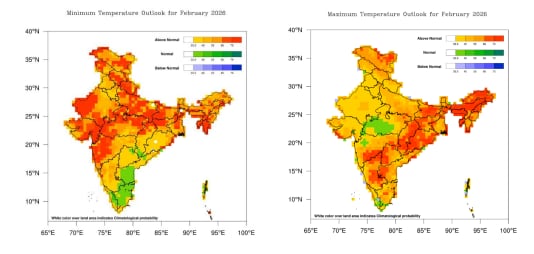
The IMD said both day and night temperatures are most likely to be above normal in most parts of the country this February, especially over the eastern states and northeast India, where the probability of a significant spike in temperatures is higher.
Meanwhile, the global ocean phenomenon La Niña is likely to persist through February and gradually move towards ENSO-neutral by March.
/images/ppid_a911dc6a-image-176988003366695743.webp)

/images/ppid_a911dc6a-image-176988003232956627.webp)
/images/ppid_a911dc6a-image-176987722904636028.webp)


/images/ppid_a911dc6a-image-176987656482689076.webp)
/images/ppid_a911dc6a-image-176987659573153683.webp)
/images/ppid_a911dc6a-image-176987653118981163.webp)