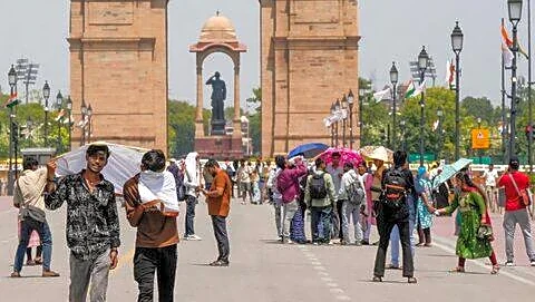


Large parts of North India are reeling under an intense and unforgiving heatwave, with conditions feeling more like late June than May. From Delhi to Banda and Jaipur to Patna, searing hot winds have disrupted daily life, leaving roads deserted during afternoons and offering little respite even after sunset.
The India Meteorological Department (IMD) has warned that the severe heat will persist for at least the next 72 hours across Delhi-NCR, Rajasthan, Uttar Pradesh, Punjab and Haryana. Temperatures in several cities are expected to touch 47°C to 48°C, with Banda currently emerging as the hottest place in the country.
Delhi-NCR remains under a red alert for heatwave conditions until May 26. Hot winds have continued since early morning hours, while
night temperatures have also remained unusually high. However, the weather department expects some relief from the night of May 22, when dust storms and light rain may begin affecting parts of the capital.
Storm And Rain Alerts Issued Across 13 States
While northern plains battle blistering temperatures, another weather system is brewing across eastern, northeastern and southern India.
The IMD has issued alerts for thunderstorms, lightning, hail and heavy rain in 13 states due to the combined influence of an active western disturbance and cyclonic circulations over the Bay of Bengal and Arabian Sea. Winds in some areas could reach speeds of 80 to 100 kmph.
Meteorologists say these systems are simultaneously influencing the Himalayan region, northern plains, coastal belts and the northeast, creating sharply contrasting weather conditions across the country.
Monsoon Advancing Faster Than Usual
Amid the extreme weather, the most significant development is the rapid progress of the southwest monsoon. According to weather experts and Skymet forecasts, the monsoon has already entered the Andaman and Nicobar Islands and is advancing faster than normal.
The IMD estimates that the monsoon could arrive in Kerala by May 26, slightly ahead of schedule. If the current pace continues, several water-stressed states and farming regions may receive early seasonal relief this year.
Pre-monsoon activity has already intensified across Kerala, Tamil Nadu, Karnataka, Maharashtra and Andhra Pradesh, with forecasts of heavy rainfall in coastal and hilly areas.
Uttar Pradesh And Rajasthan Face Brutal Conditions
In Uttar Pradesh, Bundelkhand remains the worst-hit region. Banda has crossed 48°C, while cities including Kanpur, Prayagraj, Jhansi, Varanasi, Noida and Agra remain under a yellow alert for heatwave conditions.
The IMD has indicated that western Uttar Pradesh could witness changing weather patterns after May 23, though residents have been advised to avoid outdoor activity during peak daytime hours until then.
Rajasthan continues to endure severe heat, with Chittorgarh recording 46.3°C. In western Rajasthan, heatwave conditions are expected to persist even during the night. However, dust storms and light showers may affect districts such as Ganganagar and Hanumangarh from the night of May 22.
Madhya Pradesh Records Temperatures Above 47°C
Madhya Pradesh has also witnessed dangerous heat levels across multiple districts. Khajuraho recorded 47.4°C on May 20, while Nowgong touched 46.6°C and Damoh reached 46°C.
Other major cities including Bhopal, Gwalior, Rewa and Chhatarpur have continued to face intense hot winds and oppressive nights. The weather department has warned that the heatwave is likely to continue for several more days, although isolated cloud cover may appear in some regions.
Several districts recorded temperatures above 44°C, including Mandla, Satna, Tikamgarh, Datia, Jabalpur and Umaria.
Bihar And Jharkhand Brace For Sudden Weather Changes
In contrast to the dry heat gripping central and northwestern India, Bihar could witness abrupt weather changes over the next 12 hours.
Rain, strong winds and lightning alerts have been issued for Patna, Bhagalpur, Darbhanga, Purnia and Muzaffarpur. Hailstorms are also possible in several districts, while areas near the Nepal border may experience dust storms.
Southern Bihar, including Gaya, is likely to continue facing hot winds despite the possibility of storms elsewhere in the state.
Neighbouring Jharkhand is expected to experience thunderstorms and gusty winds reaching up to 70 kmph in Ranchi, Jamshedpur, Bokaro and Dhanbad. Authorities have advised residents to avoid weak structures and trees during storm activity.
Punjab, Haryana And Chandigarh Under Red Alert
Punjab and Haryana are also battling extreme temperatures ranging between 44°C and 45°C. Cities such as Chandigarh, Hisar, Bhiwani and Patiala remain under red alert until May 26.
Although dust storms and light rainfall may bring slight relief from May 22 onwards, weather experts caution that humidity levels could rise afterwards, increasing discomfort.
Rain, Snowfall Expected In Hill States
The western disturbance is also expected to impact Himalayan states over the coming days.
In Uttarakhand, rain, hail and lightning are forecast for Chamoli, Pithoragarh and Uttarkashi from the night of May 21. Plains in the state have already crossed 40°C.
Himachal Pradesh may witness strong winds and rain in Shimla, Kangra and Mandi on May 22 and 23, with gusts reaching 40 to 50 kmph.
In Jammu and Kashmir, rain and snowfall are expected in higher-altitude areas over the next two days, likely bringing down temperatures and offering relief to tourists and residents alike.
Northeast Faces Risk Of Severe Storms
The northeast is among the regions facing the most serious storm threats this week.
Heavy rainfall and powerful storms are likely in Assam, Meghalaya, Arunachal Pradesh and Sikkim, where wind speeds may reach 80 to 100 kmph in isolated areas. Authorities have also warned about rising river levels, flooding risks and possible landslides in vulnerable hill regions.
Fishermen Warned Against Venturing Into Sea
With cyclonic circulations active over both the Arabian Sea and Bay of Bengal, the IMD has advised fishermen not to venture into the sea over the next few days.
Coastal Kerala, Tamil Nadu and parts of the western coastline are expected to witness rough sea conditions alongside intensified pre-monsoon rainfall.
Safety Advisory Issued By IMD
The weather department has urged people to take precautions amid the dual threat of heatwaves and severe storms. Residents have been advised to avoid going outdoors during afternoon hours, stay hydrated, wear light clothing and avoid direct exposure to the sun.
During thunderstorms and lightning activity, people have been asked to stay away from trees, open fields and unstable structures.
/images/ppid_a911dc6a-image-177932825539782092.webp)


/images/ppid_a911dc6a-image-177915409133845800.webp)