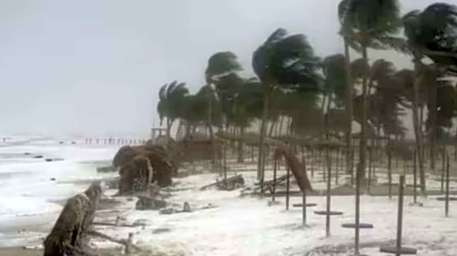

The low-pressure area over the southeast Bay of Bengal intensified into a deep depression on Sunday and is on track to intensify into Cyclone ‘Montha’ by October 27. The cyclonic storm is expected to make
landfall on the coast of Andhra Pradesh in the evening or night of October 28, with wind speeds touching 90-100 km/hour.
As per the weather agency, the system is expected to cross the coast between Machilipatnam and Kalingapatnam, around Kakinada, packing wind speeds of 90–100 kmph, gusting up to 110 kmph.
The weather system was centred on Sunday morning about 830 km southeast of Kakinada, 930 km south-southeast of Gopalpur in Odisha and 620 km west of Port Blair. The IMD said it is likely to move northwestwards and further intensify into a severe cyclonic storm by October 28 morning before making landfall that night.
Heavy Rain Alert For Coastal States
As the storm intensifies, the India Meteorological Department (IMD) has issued a heavy rain alert for Andhra Pradesh, Tamil Nadu, Odisha, and Puducherry for the next few days.
IMD Scientist S Jagannath Kumar said a red alert has been issued for several Andhra Pradesh districts, including Kakinada, Konaseema, West Godavari, Krishna, Bapatla, Prakasam and Nellore. A storm surge of about one metre above the astronomical tide is also expected along the coast, he said.
Odisha and Andhra Pradesh are bracing for very heavy to extremely heavy rainfall between October 27 and 29, while parts of West Bengal, including Kolkata, Howrah, Medinipur, South 24 Parganas, Hooghly and Bankura, are expected to receive light to moderate rain from Sunday, intensifying from October 28.
All NDRF and SDRF teams have been kept on standby and additional teams are ready for deployment during critical situations. The IMD has asked fishermen not to venture into the sea from October 26-29 along and off the coast of Tamil Nadu, Andhra Pradesh, Puducherry (Yanam) and Odisha.
Andhra Pradesh Chief Minister N Chandrababu Naidu alerted all district collectors, superintendents of police, and other senior officials about the cyclone and held a teleconference with them. Noting that the cyclone’s sphere of influence could stretch from Srikakulam to Tirupati, Naidu said heavy rains of up to 100 mm could lash the state, accompanied by gales gusting up to 110 kmph.
In Odisha, the government has placed all 30 districts on alert, with a red warning for Malkangiri, Koraput, Rayagada, Gajapati and Ganjam. Revenue and Disaster Management Minister Suresh Pujari told PTI that district collectors have been directed to evacuate residents from low-lying and flood-prone areas and to ensure readiness for rescue and relief operations.
Additionally, the Tamil Nadu government has mobilised 24,149 officials for relief, readied over 1,400 motor pumps and 103 boats, and opened more than 215 relief camps and 106 community kitchens in anticipation of flooding. Fisherfolk have been strongly advised to avoid the sea till at least October 28, and those already at sea are urged to return immediately.
(With inputs from agencies)
/images/ppid_a911dc6a-image-177086525988983382.webp)

/images/ppid_59c68470-image-177086510182449558.webp)

/images/ppid_59c68470-image-177086506429093532.webp)
/images/ppid_59c68470-image-177086513990276343.webp)
/images/ppid_59c68470-image-177086502967212737.webp)
/images/ppid_59c68470-image-177086503363688393.webp)


/images/ppid_a911dc6a-image-177086355446649864.webp)
/images/ppid_a911dc6a-image-177086352380239409.webp)