





The Great Nicobar Holistic Development Project has recently become the subject of political debate after Leader of the Opposition Rahul Gandhi raised concerns over its environmental impact and implications for tribal communities.
While these concerns deserve careful consideration, the strategic rationale underpinning the project has received comparatively little attention. Any meaningful assessment must examine both dimensions because Great Nicobar is not simply another infrastructure project—it occupies one of the most strategically significant locations in the Indo-Pacific.
The name of the project is “Holistic Development of Great Nicobar Island”. It is located on Great Nicobar, the southernmost island of the Andaman & Nicobar Islands, a Union
Territory of India. The implementing agency is the Andaman and Nicobar Islands Integrated Development Corporation (ANIIDCO). Its estimated cost is approximately Rs 81,000 crore, revised from the initial Rs 72,000 crore. The implementation horizon is approximately 30 years, to be executed in phases.
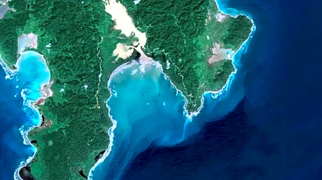
The key components include an International Container Transhipment Terminal (ICTT) at Galathea Bay, a greenfield dual-use international airport, a 450 MVA gas-and-solar power plant, and a township with supporting infrastructure.
The strategic anchors for this project are Maritime India Vision 2030, the Sagarmala Programme, Amrit Kaal Vision 2047, the Act East Policy, and the SAGAR Doctrine.
Geographic and Strategic Context
Great Nicobar lies on the western approaches to the Strait of Malacca, one of the world’s busiest maritime corridors. Indira Point, the southernmost point of the island, is situated approximately 145 km from Indonesia’s Rondo Island, while Galathea Bay lies approximately 130 nautical miles from the mouth of the Strait of Malacca. The Six Degree Channel, between Great Nicobar and Aceh, Indonesia, is approximately 200 km wide and carries a major share of east–west international shipping traffic.
The Strait of Malacca handles 20–35% of global maritime trade and approximately 80% of China’s crude oil imports, lending the project considerable geopolitical relevance.
The Andaman & Nicobar Command (ANC), India’s first tri-service command, was established in 2001. INS Baaz, India’s southernmost air station, has been operational on Great Nicobar since 2012.
Strategic Rationale
One of the key objectives is to enhance India’s maritime presence by strengthening its permanent footprint at the western entrance of the Strait of Malacca and improving maritime domain awareness in the eastern Indian Ocean.
From a naval logistics perspective, the project will provide forward operating capability for the Indian Navy and the Andaman & Nicobar Command, including support for INS Baaz.
In the context of India’s presence in the Indo-Pacific, the project complements existing arrangements such as the Sabang access agreement with Indonesia and supports Quad-aligned operational interoperability.
It will also improve sea-lane security by enhancing India’s ability to contribute to anti-piracy operations, search and rescue, counter-narcotics efforts, and submarine cable security in the region.
The project will further enable faster humanitarian assistance and disaster relief (HADR) operations, addressing a recognised capability gap exposed by the 2004 Indian Ocean tsunami.
Economic Rationale
Galathea Bay offers a natural draft of approximately 20 metres, making it one of the few locations on the Indian coastline capable of handling large mother vessels without extensive dredging.
The Phase I design capacity is approximately 4 million TEUs (twenty-foot equivalent units—the standard international unit used to measure the capacity of container ships, ports, and container terminals). The ultimate capacity at full build-out is approximately 16 million TEUs.
Currently, a significant share of Indian transhipment cargo is routed through Singapore, Colombo, Klang, and Salalah, resulting in an estimated annual revenue leakage of US$200–220 million.
A domestic transhipment hub will reduce dependence on foreign ports, retain logistics revenue within India, and ease congestion at mainland ports.
The project is also expected to generate direct and indirect employment, expand tourism, and reduce the islands’ long-standing dependence on central subsidies.
Project Footprint and Land Use
The total area of Great Nicobar Island is approximately 910 sq km. The project envelope, the Holistic Master Plan area, covers 166 sq km, or approximately 18% of the island.
Forest land proposed for diversion under the Forest (Conservation) Act is approximately 130 sq km, or around 14% of the island. Approximately 82% of the island, including Campbell Bay National Park and most of Galathea National Park, lies outside the project zone. Around 15% of the project area is proposed to be retained as green and open space.
Forest and Tree Cover
The official estimate indicates that approximately 9.64 lakh trees may be felled in phases over the 30-year implementation period.
As part of compensatory afforestation, 261.5 sq km has been committed by the Government of Haryana, in accordance with statutory norms requiring approximately double the diverted forest area.
It may be recalled that, at the national level, India’s overall forest and tree cover registered a net gain of 1,445.81 sq km between the 2021 and 2023 assessments of the India State of Forest Report (ISFR 2023).
Biodiversity and Environmental Safeguards
A Biodiversity Conservation and Management Plan has been developed jointly with the Wildlife Institute of India (WII), the Zoological Survey of India (ZSI), the Botanical Survey of India (BSI), and the Indian Council of Forestry Research and Education (ICFRE).
Species-specific recovery plans cover the leatherback turtle, Nicobar megapode, saltwater crocodile, robber crab, coral reefs, and mangroves.
The Galathea Bay Wildlife Sanctuary was denotified in 2021 to facilitate the port project. In compensation, new sanctuaries have been declared on Little Nicobar, Menchal, and Meroe Islands.
A coral translocation protocol has been put in place for affected reef areas. Eco-sensitive zoning, dedicated monitoring committees, and phased implementation form part of the environmental clearance conditions.
Tribal Communities and Safeguards
Two indigenous communities inhabit Great Nicobar: the Nicobarese, who are largely settled and integrated into formal administrative structures, and the Shompen, a Particularly Vulnerable Tribal Group (PVTG) with a population of approximately 230, according to the 2011 Census.
The Andaman and Nicobar Protection of Aboriginal Tribes Regulation, 1956, designates approximately 751 sq km of Great Nicobar as a tribal reserve. Approximately 84 sq km of this reserve falls within the project envelope and is proposed for denotification.
The project largely avoids the core inhabited zones. Gram Sabha and Tribal Council consultations have been conducted for the settled Nicobarese community.
Engagement with the Shompen is being undertaken through the Anthropological Survey of India under specific protocols, given their semi-nomadic and largely uncontacted status.
Disease-buffer protocols, restricted-access zones, and habitat protection measures are built into the project design. Much of Galathea National Park, which is used by the Shompen, lies outside the project zone.
Conclusion
The debate over the Great Nicobar Holistic Development Project must now go beyond politics and focus on facts, strategy, and implementation. Given its location at one of the world’s most critical maritime chokepoints, the project carries strategic significance that extends well beyond the Andaman and Nicobar Islands.
At the same time, environmental safeguards and the protection of indigenous communities must remain non-negotiable throughout its execution. The real test is whether India can successfully reconcile national security, economic development, and ecological stewardship. If it does, Great Nicobar could emerge as a defining example of sustainable strategic infrastructure in the Indo-Pacific.
The writer is an author and columnist. His X handle is @ArunAnandLive. Views expressed are personal and solely those of the author, and do not necessarily reflect News18’s views.






/images/ppid_a911dc6a-image-178318402537738395.webp)