
What's Happening?
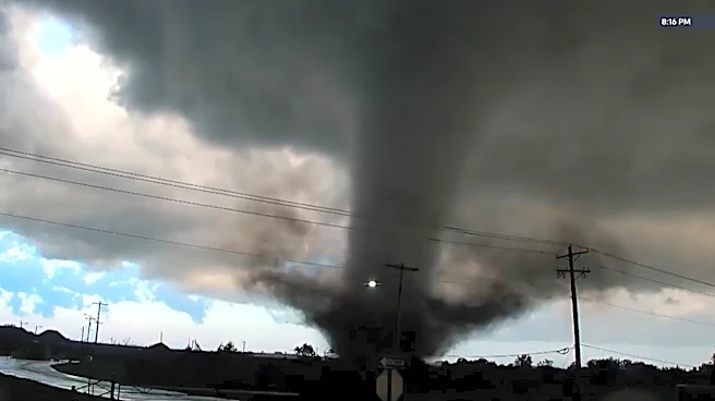
Kansas City is under a severe weather alert as thunderstorms are expected to hit the area from Thursday evening into Friday morning. The National Weather Service has issued a tornado watch for several
counties in northwestern Missouri and Kansas, including Andrew, Atchison, Holt, Nodaway, Anderson, Douglas, and Franklin. The storms are anticipated to develop between 4 p.m. and 8 p.m., with the potential for strong straight-line winds, large hail, and possibly tornadoes. The weather system is expected to move through the Kansas City metro area between 7 p.m. and 11 p.m., exiting by 2 a.m. on Friday.
Why It's Important?
The severe weather poses significant risks to residents in the affected areas, with potential damage from high winds and hail. The issuance of a tornado watch indicates a heightened level of alertness is necessary, as tornadoes can cause widespread destruction and pose a threat to life. The impact on infrastructure, homes, and businesses could be substantial, necessitating preparedness and caution from the public. The weather conditions could also disrupt transportation and daily activities, emphasizing the need for timely updates and safety measures.
What's Next?
Following the current weather system, additional risks for severe weather are anticipated on Sunday and Monday. Residents are advised to stay informed through local weather updates and to have emergency plans in place. Authorities may issue further alerts or warnings as the situation develops, and it is crucial for the community to remain vigilant and responsive to any changes in weather conditions.