

What's Happening?
A 'Super El Niño' event is currently underway, characterized by Pacific Ocean temperatures significantly warmer than average, potentially reaching 8 degrees Fahrenheit above normal. This makes it considerably stronger than any cycle peak in the past 35
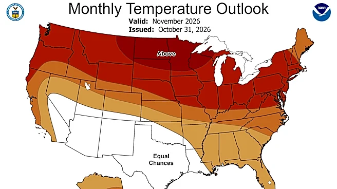
years and is on track to surpass the 1982-1983 El Niño, which was the strongest on record. El Niño, the 'warm' phase of the El Niño-Southern Oscillation (ENSO), involves warmer-than-usual ocean water west of South America, altering global wind and ocean current patterns. This shift is already causing significant weather changes, such as 20 inches of rain in parts of Ecuador in October compared to a typical 0.2 inches, and California coastlines experiencing sea levels a foot above normal, leading to erosion and large waves. While El Niño typically pulls the Pacific jet stream south, drying out U.S. states along the Canadian border, it can also destabilize the polar jet stream, potentially causing abrupt arctic cold outbreaks. Forecasters, including Montana State Climatologist Kelsey Jencso, note a leaning towards a warmer-than-normal winter for many U.S. regions, though precipitation estimates remain highly uncertain, especially inland.
Why It's Important?
The Super El Niño carries significant implications for various U.S. regions and sectors. For the Northern Rocky Mountains and Greater Yellowstone, while typically experiencing drier and warmer conditions during El Niño, the extreme strength of this event introduces high uncertainty in precipitation forecasts. This could impact water resources, agriculture, and winter tourism, as exemplified by Bridger Bowl Ski Area closing early last April due to a warm spell. Coastal areas, particularly California, are already facing increased sea levels and erosion, posing risks to infrastructure and homes. The potential for more frequent storm systems, as noted by Jencso, could lead to increased instances of severe weather across the country. Furthermore, the destabilization of the polar jet stream could bring unexpected cold snaps, affecting energy demands and transportation. The unpredictability of this Super El Niño challenges traditional forecasting models, making preparedness difficult for communities and industries reliant on stable weather patterns.
What's Next?
As the Super El Niño continues to develop, its peak influence is expected during the winter months (December, January, and February). Following this peak, El Niño conditions typically begin to revert towards average during the subsequent spring and summer. However, NOAA forecasters caution that confidence in predictions for the North Central region during spring and summer 2027 is substantially lower, as El Niño's influence on North American climate weakens considerably beyond early spring. This uncertainty means that while immediate winter impacts are being closely monitored, long-term planning for the following warm season remains challenging. Stakeholders, including water managers in Montana and Wyoming, are advised to consider the potential for reduced snow accumulation and earlier snowmelt. Research efforts, such as those at Montana State University utilizing artificial intelligence, are underway to improve hydrological outlooks and better predict precipitation formation and distribution, aiming to enhance forecasting accuracy for future weather events.
Beyond the Headlines
The current Super El Niño highlights a broader challenge in understanding and predicting complex climate phenomena, especially as they interact with other environmental changes. A recent study by Montana State University researchers found that winter heatwaves are not melting snow in predictable fashion, with nearly half of the studied sites showing no corresponding boost in river and stream levels despite significant snowmelt. This disconnect between snowmelt and streamflow, where meltwater is not recharging rivers, poses critical questions for water resource management, particularly for irrigators and fisheries biologists who rely on accurate predictions of summer water supplies. The ongoing research into where this water goes—whether evaporating or soaking into soil—underscores the intricate hydrological processes at play. This situation also emphasizes the need for advanced technological solutions, such as AI-driven forecasting models, to decipher these complex interactions and provide more reliable climate predictions in an era of increasingly extreme and unpredictable weather patterns.