


What is the story about?
What's Happening?
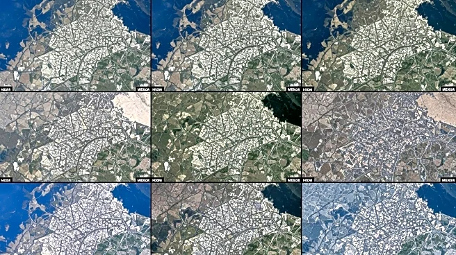
NASA researchers, led by Jody Vogeler from Colorado State University, are employing satellite data to analyze urbanization trends in Mekele, Ethiopia, as part of a broader study on Africa's rapidly growing cities. The project focuses on 'secondary cities'—urban areas with populations over 100,000 that are not the largest in their countries. Mekele, located in Ethiopia's Tigray region, has transformed from a town of 60,000 in 1984 to a city of over 500,000 by 2025. This growth includes planned developments and unplanned settlements, which pose challenges for infrastructure and services. The research aims to provide data products useful for city governments and urban planners, including annual land-cover maps for cities in Ethiopia, Nigeria, and South Africa.
Why It's Important?
The study of urbanization in Mekele and similar cities is crucial as Africa's population is expected to reach 2.5 billion by 2050, with significant growth in urban areas. Understanding these trends can help address challenges such as infrastructure lag and unplanned settlements, which can lead to economic and social issues. The data generated by this research can aid in sustainable urban planning, aligning with United Nations' development goals. This work highlights the importance of focusing on secondary cities, which often experience rapid growth without adequate planning, potentially impacting economic development and quality of life.
What's Next?
The ongoing project will continue to develop and refine land-cover maps and other data products to assist urban planners and policymakers in managing urban growth effectively. The insights gained from Mekele and other pilot cities could inform strategies for sustainable urban development across Africa. As the project progresses, it may influence policy decisions and investment in infrastructure to support rapidly growing urban populations.
Beyond the Headlines
The research underscores the ethical and practical challenges of urbanization, particularly in regions with limited resources. It raises questions about equitable development and the role of technology in addressing urban challenges. The project also highlights the potential for satellite data to provide critical insights into urban growth patterns, offering a model for similar studies worldwide.