


What's Happening?
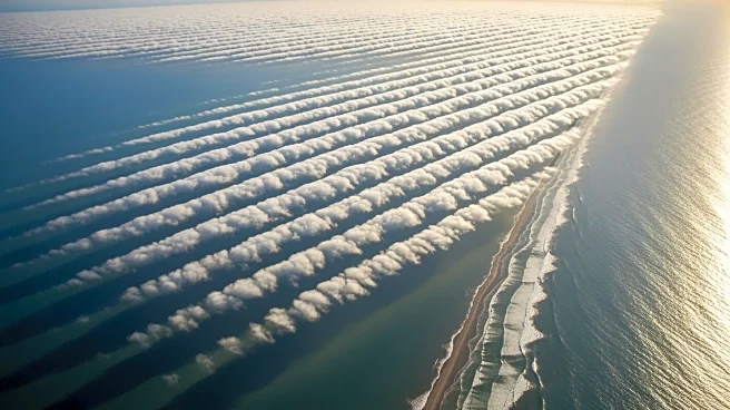
The National Oceanic and Atmospheric Administration (NOAA) has unveiled a captivating image of 'cloud streets' forming off the south Florida coast. This phenomenon occurred on February 1, 2026, as a wave of freezing air moved southward into the Gulf of Mexico
and the Atlantic Ocean. These cloud streets are created when cold air passes over warmer water, absorbing moisture and forming parallel belts of low-level clouds. The image was captured by the Advanced Baseline Imager on NOAA's GOES-19 weather satellite, which orbits 22,236 miles above Earth's equator. This satellite, launched in June 2024, is equipped to monitor terrestrial weather and environmental hazards, including conditions that can lead to hurricanes.
Why It's Important?
The formation of cloud streets is a significant meteorological event that highlights the interaction between atmospheric conditions and oceanic surfaces. This phenomenon can provide insights into weather patterns and help meteorologists predict future weather events. The data collected by the GOES-19 satellite is crucial for understanding and forecasting severe weather conditions, which can have widespread impacts on communities, especially in regions prone to hurricanes. The ability to monitor such events from space enhances preparedness and response strategies, potentially saving lives and reducing economic losses.
What's Next?
As NOAA continues to monitor weather patterns using advanced satellite technology, further studies on cloud streets and similar phenomena could improve predictive models for severe weather. This ongoing research is vital for enhancing the accuracy of weather forecasts and understanding the broader implications of climate dynamics. Stakeholders, including government agencies and emergency services, may use this data to refine disaster preparedness plans and mitigate the impacts of extreme weather events.