






What's Happening?
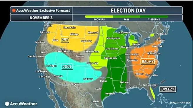
Asheville, North Carolina, is experiencing an unseasonably warm beginning to November, with temperatures expected to reach the 70s. According to the National Weather Service, clouds are projected to clear on Monday, November 2, leading to warmer weather
across the mountains, with Asheville seeing a high near 66 degrees. This warming trend is set to continue into Tuesday, with sunny skies and temperatures potentially reaching 70 degrees, which is 7 to 10 degrees above average for early November. However, this pattern is expected to shift by Wednesday, as a cold front approaches the mountains, bringing a 60% chance of rain, mainly after 3 p.m. Rain chances will increase to 80% on Wednesday night, with isolated thunderstorms also possible after 10 p.m. While some showers could be heavy, widespread flooding is not anticipated due to recent dry conditions and the front's relatively quick movement. Rain may linger into early Thursday, with a high of 72 degrees, before drier weather returns by Friday, with partly sunny skies and a high near 70.
Why It's Important?
The fluctuating weather patterns in Asheville, from unseasonably warm temperatures to impending rain and potential thunderstorms, have several implications for residents and visitors. The warm start to November could impact local businesses that rely on typical fall weather for tourism, such as those offering outdoor activities or seasonal events. Conversely, the mild temperatures might extend the season for other outdoor pursuits. The forecast for rain and possible thunderstorms mid-week could disrupt outdoor plans and events, requiring adjustments for local businesses and individuals. While widespread flooding is not expected, localized heavy rain could still pose minor inconveniences. Understanding these weather shifts is crucial for planning daily activities, travel, and for local authorities to prepare for any potential weather-related issues, even if minor.
What's Next?
Residents and visitors in Asheville should monitor weather updates closely, especially for Wednesday and Thursday, to prepare for rain and potential thunderstorms. Those with outdoor plans or travel arrangements during the mid-week period may need to make adjustments. Local businesses, particularly those in tourism and hospitality, might need to adapt their operations or offer indoor alternatives in response to the changing weather. Emergency services will likely remain vigilant for any localized impacts, though the overall threat of severe weather is low. By Friday, the return to drier, partly sunny conditions should allow for a resumption of typical activities, concluding this period of weather variability.
Beyond the Headlines
The unseasonably warm temperatures followed by a cold front and rain in Asheville highlight broader climate trends and their impact on local weather patterns. Such variability can affect seasonal expectations, influencing everything from agricultural cycles to tourism marketing strategies. For a region known for its natural beauty and outdoor activities, shifts in typical seasonal weather can have long-term implications for ecological systems and local economies. The ability of forecasters to predict these changes, even with low risk of severe impact, underscores the importance of meteorological science in public safety and economic planning. This event serves as a micro-example of how communities must increasingly adapt to and plan for less predictable weather conditions.