


What's Happening?
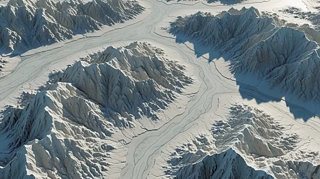
A team of international researchers, led by the University of Edinburgh, has unveiled a detailed map of Antarctica's subglacial landscape using a novel mapping technique called Ice Flow Perturbation Analysis (IFPA). This method, which combines the physics
of ice flow with satellite observations, has provided unprecedented insights into the continent's hidden topography. The map reveals large mountain ranges, deep canyons, and wide valleys, as well as tens of thousands of previously undiscovered hills and valleys beneath the ice. This discovery is significant as it offers new data that could aid scientists in understanding and addressing climate change. The Antarctic Ice Sheet, which holds about 70% of the Earth's freshwater, is the largest ice mass on the planet, and its subglacial features play a crucial role in influencing ice flow and sea level rise.
Why It's Important?
The detailed mapping of Antarctica's subglacial landscape is crucial for climate science, as it provides new insights into the continent's geological features that affect ice flow dynamics. Understanding these features is essential for predicting how the Antarctic Ice Sheet will respond to climate change and contribute to global sea level rise. The map serves as a guide for future scientific surveys, helping to focus research efforts on areas that are critical for understanding ice sheet behavior. This knowledge is vital for developing accurate models to predict sea level changes, which have significant implications for coastal communities and global climate policy. The research highlights the importance of technological advancements in satellite observations and mapping techniques in uncovering hidden aspects of our planet's geography.
What's Next?
The new map of Antarctica's subglacial landscape will likely lead to more targeted scientific surveys and research efforts in the region. Scientists may focus on areas identified by the map to conduct detailed studies on ice flow dynamics and their impact on sea level rise. The findings could influence climate models and inform policy decisions related to climate change mitigation and adaptation strategies. Additionally, the mapping technique used in this study could be applied to other glaciated regions, providing further insights into the Earth's cryosphere and its role in the global climate system.
Beyond the Headlines
The discovery of Antarctica's hidden landscapes beneath its ice sheet not only advances scientific understanding but also raises questions about the ethical and environmental implications of exploring and potentially exploiting these remote regions. As technology enables more detailed exploration, there may be increased interest in the natural resources that could be present beneath the ice. This could lead to debates about the preservation of Antarctica's pristine environment versus the potential benefits of resource extraction. The findings also underscore the importance of international cooperation in scientific research, as the study involved researchers from multiple countries working together to achieve a common goal.