


What's Happening?
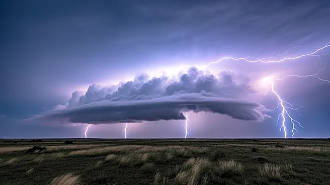
North Texas experienced severe weather conditions on Saturday night, including tornadoes, large hail, intense winds, and significant flash flooding. The storms, which were deadly, began with a supercell in Wichita County around 4 PM and lasted nearly
12 hours, dissipating early Sunday morning. A dryline to the west was identified as the key trigger for these destructive storms. The atmospheric conditions suggest a continued, albeit isolated, threat of severe weather on Sunday, with a stronger atmospheric cap reducing the likelihood of severe storm initiation. The region is expected to remain muggy, breezy, and cloudy, with temperatures in the upper 80s and southeast winds gusting up to 25 mph. The Storm Prediction Center has issued another First Alert Weather Day for Tuesday, highlighting a risk for severe weather across most of North Texas due to an approaching cold front.
Why It's Important?
The severe weather in North Texas has significant implications for the region, particularly in terms of public safety and infrastructure. The deadly storms underscore the need for effective emergency preparedness and response strategies to protect residents and minimize damage. The potential for continued severe weather poses ongoing risks, including property damage, power outages, and disruptions to daily life. Additionally, the forecasted rain could provide relief to drought-stricken areas, highlighting the complex interplay between weather patterns and regional water resources. The situation calls for heightened awareness and readiness among residents and local authorities to mitigate the impact of future storms.
What's Next?
Residents of North Texas are advised to stay alert and prepared for potential severe weather in the coming days. The Storm Prediction Center's forecast for Tuesday indicates a heightened risk of severe weather, particularly in counties northeast of the metroplex. This includes the possibility of damaging winds, hail, flooding, and tornadoes. Local authorities and emergency services are likely to remain on high alert, ready to respond to any developments. The anticipated cold front may bring cooler temperatures and much-needed rain to drought-affected areas, offering some respite from the dry conditions. Continued monitoring of weather updates and adherence to safety protocols will be crucial for minimizing risks.