



What's Happening?
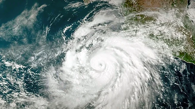
Tropical Storm Pena has formed in the Pacific Ocean, located well south of the Hawaiian islands. As of Friday, Pena had maximum sustained winds of 45 mph (72 kph). The storm was centered approximately 650 miles (1,046 kilometers) southeast of South Point,
Hawaii, and about 1,350 miles (2,173 kilometers) east-southeast of Johnston Island, according to an advisory from the Miami-based U.S. National Hurricane Center. Pena is currently moving west at 12 mph (19 kph). The Pacific Ocean has experienced an active hurricane season, partly attributed to the El Niño phenomenon.
Why It's Important?
While Tropical Storm Pena is expected to remain offshore of Hawaii and currently poses no direct threat to land, its formation and projected strengthening are important for maritime interests and long-range weather forecasting. The active hurricane season in the Pacific, influenced by El Niño, highlights the dynamic nature of global weather patterns and their potential to impact U.S. territories and shipping lanes. Even distant storms can generate swells and rip currents that affect coastal areas, posing risks to beachgoers and mariners. Monitoring such systems is crucial for the U.S. National Hurricane Center to provide timely warnings and ensure preparedness for any potential shifts in trajectory or intensity that could eventually threaten landmasses or critical infrastructure.
What's Next?
Tropical Storm Pena is forecast to strengthen over the next day or so, after which it is expected to maintain its intensity without significant change through next week. The system is projected to remain offshore of Hawaii, and currently, no watches or warnings are in effect for any land areas. There are no immediate hazards affecting land. The U.S. National Hurricane Center will continue to monitor the storm's progression and provide updates as necessary. Maritime interests in the central Pacific will need to track Pena's path and intensity to ensure safe operations, while residents in Hawaii should remain aware of potential indirect impacts such as increased ocean swells.
Beyond the Headlines
The formation of Tropical Storm Pena, particularly within an active El Niño-influenced hurricane season, underscores the complex interplay of oceanic and atmospheric conditions that drive tropical cyclone activity. El Niño typically leads to warmer sea surface temperatures in the central and eastern Pacific, which can fuel more intense and frequent storms. This event serves as a reminder of the broader climate patterns affecting weather phenomena globally and regionally. The continuous monitoring by agencies like the U.S. National Hurricane Center is not just about immediate threat assessment but also contributes to a deeper understanding of climate science and the development of more accurate long-term climate models, which are critical for future disaster preparedness and mitigation strategies.