
What's Happening?
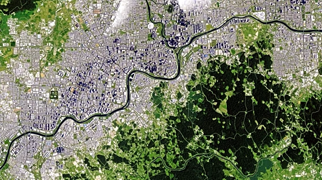
NASA's Landsat program is playing a crucial role in monitoring urban development and its environmental impacts. The program uses satellite data to capture patterns of urban growth, enabling city planners
to assess land use changes and plan future developments. With nearly 60% of the world's population now living in urban areas, the data provided by Landsat is essential for understanding the human impact on landscapes. The program's sensors, with a spatial resolution of 30 meters, allow for detailed observation of urban growth, including the detection of impervious surfaces like concrete and asphalt, which affect water infiltration and pollution. Additionally, Landsat's thermal imaging capabilities help identify urban heat islands, where city temperatures can be significantly higher than surrounding rural areas. This data is vital for urban planners and decision-makers to manage urban sprawl, land use efficiency, and the environmental consequences of urbanization.
Why It's Important?
The information provided by Landsat is critical for urban planners and policymakers as they address the challenges of rapid urbanization. By understanding the extent and impact of urban growth, cities can develop strategies to mitigate negative environmental effects, such as increased pollution and altered hydrological cycles. The ability to monitor impervious surfaces and heat islands helps in designing more sustainable urban environments that reduce energy consumption and improve air quality. Furthermore, the data can inform policies aimed at enhancing urban resilience to climate change by identifying areas most affected by heat and pollution. As urban areas continue to expand, the insights gained from Landsat data will be increasingly important for balancing development with environmental sustainability.
What's Next?
As urbanization continues to accelerate, the demand for detailed and reliable data on urban growth will increase. NASA's Landsat program is expected to continue providing valuable insights into urban development patterns, supporting efforts to create more sustainable and resilient cities. Future advancements in satellite technology may enhance the resolution and accuracy of data, offering even more precise information for urban planning. Additionally, collaboration between NASA and urban planners could lead to the development of new tools and models that integrate Landsat data with other environmental and socio-economic datasets, further improving urban management and policy-making.