


What's Happening?
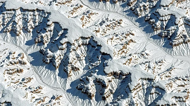
NASA's International Space Station (ISS) recently captured striking images of the Grand Canyon covered in snow, following a winter storm that swept across Arizona's high desert. The photographs, taken on January 26, 2026, by an astronaut aboard the ISS,
reveal the dramatic interplay of light and shadow across the canyon's topography. The storm had previously led to hazardous conditions, prompting the closure of Desert View Drive along the South Rim of the Grand Canyon National Park. The South Rim, at an elevation of approximately 7,000 feet, and the North Rim, at about 8,000 feet, were both blanketed in snow. The images, taken with a Nikon Z9 digital camera, were enhanced to improve contrast and remove lens artifacts, providing a clear view of the snow-covered landscape. This visual phenomenon, known as relief inversion, creates an illusion that makes the canyon appear more like a mountain range due to the angle of sunlight.
Why It's Important?
The images captured by the ISS not only provide a unique perspective on the Grand Canyon but also highlight the impact of winter storms on national parks and their accessibility. The closure of roads and trails due to hazardous conditions underscores the challenges faced by park officials in maintaining safety for visitors. Additionally, these images contribute to scientific research and public awareness by offering a visual record of weather patterns and their effects on natural landmarks. The availability of such images to the public and scientists supports educational and research initiatives, enhancing understanding of Earth's dynamic systems.
What's Next?
As winter continues, further monitoring of weather conditions in the Grand Canyon and other national parks will be crucial to ensure visitor safety and park preservation. NASA's ongoing efforts to capture and share images from space will continue to provide valuable data for scientists studying climate patterns and their effects on Earth's landscapes. The collaboration between NASA and national parks may also lead to improved strategies for managing natural resources and responding to environmental changes.
Beyond the Headlines
The use of space-based photography to document Earth's features offers a broader understanding of how natural phenomena like snowstorms affect iconic landscapes. This approach not only aids in scientific research but also enhances public appreciation for natural wonders. The images serve as a reminder of the interconnectedness of Earth's systems and the importance of preserving these environments for future generations.