


What's Happening?
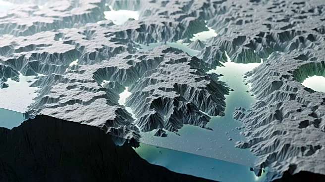
Researchers have unveiled a groundbreaking high-resolution map of Antarctica's subglacial landscape, revealing tens of thousands of previously unseen geological features. This map, developed using satellite data and physics-based modeling, provides the
most detailed view yet of the continent's hidden topography beneath its thick ice sheet. Among the discoveries is a vast bedrock channel in the Maud Subglacial Basin, stretching nearly 400 kilometers in length. The new map fills in significant gaps left by earlier radar surveys, offering a more complete understanding of the terrain that influences ice sheet behavior. This advancement promises to enhance scientific knowledge of how Antarctic ice may respond to environmental changes.
Why It's Important?
The unveiling of this detailed map is a significant scientific achievement, as it provides critical insights into the subglacial features that affect ice flow and stability in Antarctica. Understanding these hidden landscapes is crucial for predicting the future behavior of ice sheets, which has direct implications for global sea level rise. The map's ability to reveal the complex terrain beneath the ice allows researchers to better model and anticipate changes in ice dynamics, which is essential for climate change studies. This development could influence international climate policy and inform strategies to mitigate the impacts of rising sea levels on coastal communities worldwide.
What's Next?
The new map sets the stage for further research into Antarctica's subglacial environment. Scientists are likely to use this data to refine models of ice sheet dynamics and improve predictions of future ice loss. The map may also guide future expeditions and research projects aimed at exploring these newly discovered features. As the scientific community digests this information, it could lead to collaborations across disciplines to address the broader implications of these findings on climate science and policy. Additionally, the map may inspire technological advancements in remote sensing and modeling techniques, further enhancing our understanding of Earth's polar regions.
Beyond the Headlines
Beyond its immediate scientific applications, the map of Antarctica's subglacial terrain highlights the importance of technological innovation in uncovering Earth's hidden landscapes. It underscores the potential for satellite and modeling technologies to transform our understanding of remote and inaccessible regions. This development also raises questions about the ethical and environmental considerations of exploring and potentially exploiting these newly revealed areas. As interest in Antarctica's resources grows, the international community may need to revisit agreements on the preservation and use of the continent's natural resources, balancing scientific exploration with environmental stewardship.