
What's Happening?
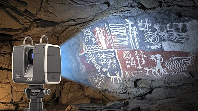
3D LiDAR technology is transforming archaeological research by providing detailed insights into ancient sites. A recent study conducted by researchers from the University of Seville utilized this technology to map La Pileta Cave in Spain, revealing previously unseen prehistoric rock art and cave features with remarkable precision. The cave, a National Monument since 1924, is renowned for its prehistoric motifs, including animal figures and symbolic markings dating from the Upper Paleolithic to the Bronze Age. Traditional methods of capturing these details, such as sketching or photography, often fell short in accuracy. However, LiDAR technology, which uses laser beams to measure distances and create accurate 3D maps, has revolutionized this process. The research team employed both mobile LiDAR devices and terrestrial scanners to capture the cave's morphology, ensuring a comprehensive and precise model of the cave's interior.
Why It's Important?
The use of 3D LiDAR technology in archaeology represents a significant advancement in the preservation and study of ancient art and artifacts. By providing a highly accurate and detailed model of La Pileta Cave, researchers can ensure that these prehistoric artworks are preserved for future generations. This technology allows for a more comprehensive understanding of the cave's historical and cultural significance, offering insights into the spatial relationships between rock art, cave structures, and artifacts. The ability to capture previously overlooked features, such as faint or eroded symbols, enhances the accuracy of archaeological analysis and preservation efforts. This development not only benefits the field of archaeology but also contributes to the broader understanding of human history and cultural heritage.
What's Next?
The integration of LiDAR data with archaeological artifacts from La Pileta Cave offers a holistic understanding of the site's significance. Researchers may continue to explore other prehistoric sites using this technology, potentially uncovering new insights into ancient civilizations. The detailed 3D models created through LiDAR imaging can be used for further analysis and preservation, ensuring that these cultural treasures are protected for future study. As the technology becomes more accessible, it may be adopted by other archaeological teams worldwide, leading to a broader application in the study and preservation of historical sites.
Beyond the Headlines
The use of 3D LiDAR technology in archaeology raises important ethical considerations regarding the preservation of cultural heritage. As researchers gain access to more detailed data, there is a responsibility to ensure that these findings are used to protect and preserve ancient sites. Additionally, the technology's ability to capture intricate details may lead to new discoveries that challenge existing historical narratives, prompting a reevaluation of our understanding of prehistoric cultures.