


What's Happening?
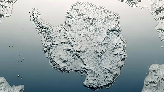
A team of researchers has created a highly detailed map of Antarctica's landscape beneath its ice cover, using satellite data and computer models of glacial movements. This new map, published in the journal Science, reveals intricate details of the continent's
topography, including high-relief alpine valleys, scoured lowlands, and deeply eroded ice stream troughs. The study, led by Dr. Helen Ockenden from the University of Grenoble-Alpes, provides a more comprehensive view than previous geophysical surveys, which relied on traditional ground and air radar measurements. These earlier methods mapped the continent in lines several kilometers apart, requiring extrapolation to fill in gaps. The new imagery offers a clearer, more precise understanding of the Antarctic landscape, akin to upgrading from a grainy pixel film camera to a high-resolution digital image.
Why It's Important?
The development of this detailed map is significant for several reasons. It enhances the scientific community's ability to project ice loss and sea level rise, critical factors in understanding and mitigating the impacts of climate change. By providing a more accurate depiction of the sub-ice topography, researchers can better predict how the ice sheet will respond to warming temperatures and contribute to global sea level changes. This information is vital for policymakers and environmental planners as they develop strategies to address the challenges posed by rising sea levels. Additionally, the map could inform future scientific explorations and research initiatives in Antarctica, offering new insights into the continent's geological history and its role in the Earth's climate system.
What's Next?
The release of this map sets the stage for further research and exploration in Antarctica. Scientists may use the detailed topography to refine climate models and improve predictions of ice sheet dynamics. This could lead to more accurate forecasts of sea level rise, informing global climate policy and adaptation strategies. Additionally, the map may guide future expeditions to the continent, helping researchers identify areas of interest for geological and environmental studies. As the scientific community continues to analyze the data, there may be new discoveries about the processes shaping Antarctica's landscape and their implications for the global climate.
Beyond the Headlines
Beyond its immediate scientific applications, the map of Antarctica's sub-ice landscape could have broader implications for understanding Earth's geological processes. The detailed imagery may reveal previously unknown features and formations, offering insights into the continent's geological history and the forces that have shaped it over millions of years. This knowledge could contribute to a deeper understanding of plate tectonics, glacial dynamics, and the interactions between Earth's surface and its climate. Furthermore, the map may inspire new interdisciplinary research, bringing together experts in geology, climatology, and environmental science to explore the complex relationships between Antarctica's landscape and the global climate system.