


What's Happening?
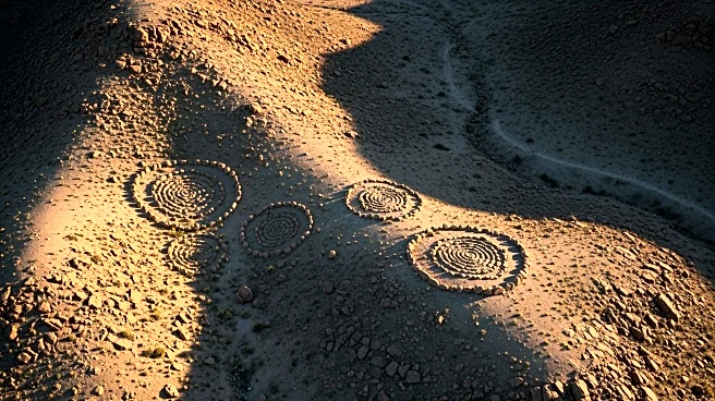
Researchers from Ben-Gurion University have discovered 28 additional large stone circles near Rujm el-Hiri, often referred to as 'Israel's Stonehenge.' This discovery was made using satellite imagery and environmental analysis, revealing that Rujm el-Hiri is part
of a larger network of ancient megalithic structures. The site, located in the Golan Heights, dates back to the Early Bronze Age and consists of concentric stone walls. The newly identified circles, constructed from local basalt, suggest a broader social and economic system in the region. These findings challenge previous interpretations of Rujm el-Hiri's function, suggesting it may have served as a ritual gathering place or territorial marker.
Why It's Important?
The discovery of additional stone circles near Rujm el-Hiri provides new insights into the social and economic systems of ancient communities in the region. It highlights the potential for satellite technology to uncover hidden archaeological sites, offering a more comprehensive understanding of historical landscapes. This research could reshape our knowledge of ancient societies in the Southern Levant, influencing future archaeological studies and conservation efforts. The findings also underscore the importance of integrating advanced remote sensing techniques in archaeological research.
Beyond the Headlines
The use of satellite imagery in archaeology represents a significant advancement in the field, allowing researchers to explore areas that are otherwise inaccessible due to geopolitical or environmental challenges. This approach not only aids in the discovery of new sites but also enhances the understanding of existing ones by providing a broader context. The integration of technology in archaeology could lead to more discoveries and a deeper understanding of human history.