





What's Happening?
Arizona is bracing for a significant storm system this Halloween weekend, which is expected to deliver rain, strong winds, and cooler temperatures across the state. According to ABC15, showers and storms have already commenced in parts of the Valley early
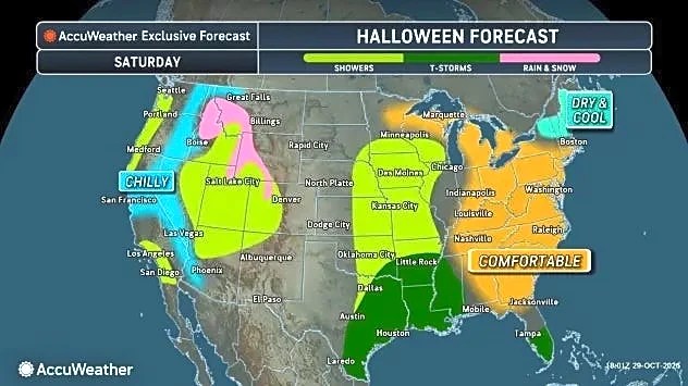
Friday morning, with more widespread activity anticipated throughout the day, peaking from late morning into early evening. Some of these storms could escalate to severe levels, potentially bringing damaging winds and hail. Flood Watches have been issued for much of Arizona, including the Valley, effective Friday and extending from late Saturday night through Sunday. While Saturday might see a brief lull with isolated showers, rain chances are projected to increase again late Saturday night, after most trick-or-treating activities conclude. Sunday is expected to bring widespread, soaking rain across Arizona, prompting ABC15 to declare Friday and Sunday as Weather Action Days due to potential impacts on outdoor events and the risk of flooding.
Why It's Important?
This storm system carries significant implications for residents and infrastructure across Arizona. The potential for severe storms, damaging winds, and hail poses risks to property and personal safety. The Flood Watches in effect highlight the concern for localized flooding, which can disrupt transportation, damage homes, and create hazardous conditions. For the agricultural sector, while rain is generally beneficial, excessive or rapid rainfall can lead to erosion and crop damage. Businesses reliant on outdoor activities, particularly during the Halloween weekend, may experience significant disruptions and financial losses. The cooler temperatures, while a welcome change for some, could also impact energy consumption patterns. Furthermore, the report notes a trend of Phoenix becoming drier, with new average monsoon and yearly rainfall figures showing a decrease, making significant rain events like this crucial for water replenishment but also potentially more impactful due to hardened ground.
What's Next?
Residents in Arizona are advised to take immediate action to prepare for the anticipated weather changes. This includes securing outdoor items, monitoring weather alerts, and having emergency plans in place. The Valley could see 1 to 2 inches of rain from Friday through Sunday, with higher elevations potentially receiving 2 to 3 inches. Isolated showers are also possible early Monday, primarily in eastern Arizona, before drier conditions are expected to return. Valley high temperatures are forecast to remain in the mid to upper 70s on Friday and Saturday, dropping into the low 70s by Sunday. The ongoing monitoring of rainfall totals, especially in relation to the updated average monsoon and yearly rainfall figures for Phoenix, will be critical for understanding long-term climate trends and water management strategies in the region.
Beyond the Headlines
The recurring nature of significant weather events, such as this storm system, underscores broader discussions around climate patterns and urban development in arid regions like Arizona. The updated rainfall averages for Phoenix, indicating a drier trend, highlight the increasing importance of water conservation and resilient infrastructure. While individual storms provide temporary relief, the long-term decline in average rainfall suggests a need for sustained adaptation strategies. The impact of such events on local ecosystems, particularly the desert flora and fauna, can be complex, ranging from beneficial water replenishment to potential disruption of habitats. The community's response to these weather challenges, including emergency preparedness and resource management, will continue to shape the region's ability to thrive amidst evolving environmental conditions.