







What's Happening?
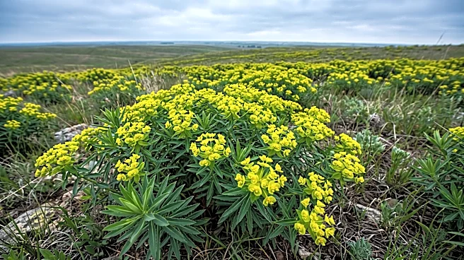
Scientists at the University of Minnesota have developed a new method to track the spread of leafy spurge, an invasive plant, using satellite imagery and AI deep-learning models. This research, funded by the University of Minnesota’s Minnesota Invasive
Terrestrial Plants and Pests Center and the USDA National Institute of Food and Agriculture, has revealed a significant increase in the plant's abundance, specifically a 570% rise between 2000 and 2021. The study, published in Ecological Applications, combined real observations of leafy spurge, including community data from the iNaturalist app, with open-source Landsat imagery from the U.S. Geological Survey and NASA satellites. The findings indicate that major increases in leafy spurge occurred primarily around Fargo-Moorhead and Minneapolis-Saint Paul, and that the plant often appears near roadways. Additionally, detection of newly-invaded areas through satellite imagery has improved forecasts for future invasions.
Why It's Important?
The rapid spread of leafy spurge poses a significant economic threat to U.S. farmers and ranchers, having caused approximately $1 billion in losses between 1960 and 2000. The plant's toxic sap, released when damaged, is harmful to livestock, and its dense patches can cover vast areas, impacting agricultural productivity. This new AI-driven tracking method is crucial for improving the capacity to monitor invasive species dynamically and prioritize limited resources for management. By providing accurate forecasts of future invasion areas, state and federal agencies can implement more effective and targeted management strategies. This technological advancement reduces bias in detection, allowing for the identification of invasions in areas that might otherwise be overlooked by human observers, thereby safeguarding agricultural lands and mitigating economic damage.
What's Next?
Researchers plan to extend the application of this AI-driven method and technology to detect the spread of other invasive species. The improved forecasts for future invasions will inform state and federal agencies, enabling them to develop more proactive and efficient management plans. Given the economic damage caused by leafy spurge, farmers, ranchers, and state agencies are particularly interested in understanding and predicting its spread. Proactive roadway management strategies could be implemented to slow the plant's invasion, as the study found a correlation between leafy spurge presence and roadways. The continued development and application of this technology could lead to a more comprehensive and effective national strategy for managing invasive plant species.
Beyond the Headlines
The integration of artificial intelligence and satellite technology in environmental monitoring represents a significant shift in conservation efforts. This approach moves beyond traditional, often labor-intensive, methods of tracking invasive species, offering a more scalable and precise solution. The use of community science data, such as observations from the iNaturalist app, highlights the growing potential of citizen participation in scientific research and environmental protection. This collaborative model, combining advanced technology with public engagement, could set a precedent for addressing other widespread ecological challenges. Furthermore, the ability to predict invasion patterns with greater accuracy raises ethical considerations regarding resource allocation and the potential for preemptive interventions, balancing ecological preservation with economic interests.