
What's Happening?
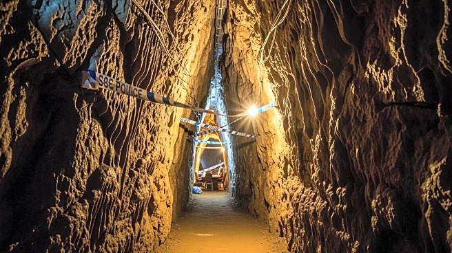
In southern Spain, explorers have successfully linked two deep caves into a single 'supercave system' that stretches approximately 16.4 miles. This significant geological discovery is located within the Sierra
de las Nieves near Málaga. The project was spearheaded by the Underground Exploration Group of the Excursionist Society of Málaga, which has been dedicated to systematic cave mapping and ensuring safe access to complex cave systems. The newly connected cave network could potentially extend to around 31 miles if additional nearby passages are linked. This supercave also includes a known water cave, suggesting a larger underground drainage system, which is valuable for studying water movement in limestone mountains. The discovery marks a significant advancement in underground science and hazard planning for the region, providing insights into how floods traverse through rock formations during heavy rainfall.
Why It's Important?
The creation of this supercave system is a major milestone for geological and hydrological research. It offers a unique natural laboratory for studying water tracking in limestone mountains, which is crucial for understanding regional water budgets and flood dynamics. The detailed mapping of the cave system can enhance models predicting the movement of water, silt, and pollutants, thereby aiding in environmental management and conservation efforts. Additionally, the supercave provides a habitat for specialized cave-dwelling organisms, known as troglobionts, which are adapted to life in constant darkness. Protecting these fragile ecosystems is essential, as disturbances can have significant impacts on the food webs within these environments. The discovery also emphasizes the importance of responsible exploration practices, including minimizing human impact and ensuring safety protocols are followed.
What's Next?
Following the connection of the caves, researchers are set to embark on extensive studies involving geology, hydrology, and biology. Future exploration campaigns will focus on identifying junctions where small side tubes might connect to neighboring caves, further expanding the network. Accurate elevation data will be collected to understand how stormwater moves through the cave system. The findings will contribute to a broader understanding of karst landscapes, which are formed by the dissolution of rock such as limestone. These studies will provide valuable insights into climate history, as mineral formations within the caves record past rainfall patterns. The ongoing research will require collaboration among scientists to ensure comprehensive data collection and analysis.
Beyond the Headlines
The discovery of the supercave system highlights the importance of patience, precision, and teamwork in scientific exploration. It serves as a reminder of how surface activities, such as paving and water pumping, can have long-lasting effects on underground environments. The mapping of the cave system transforms hidden spaces into accessible data, allowing for informed decision-making in environmental management. The project underscores the need for continued investment in speleology, the scientific study of caves, to uncover the mysteries of subterranean landscapes and their ecological significance.