
What's Happening?
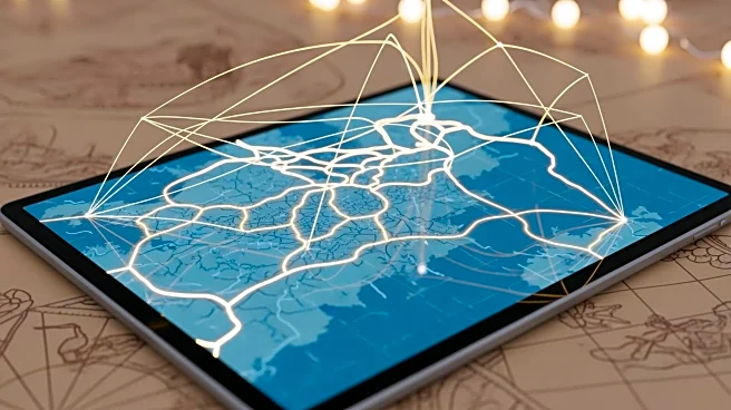
Researchers have developed Itiner-e, an interactive digital map that traces approximately 300,000 kilometers of ancient Roman roads. This project, described as a 'Google Maps for Roman roads,' reveals
a more extensive network than previously believed, covering Europe, Great Britain, North Africa, and the Middle East. The map provides detailed metadata, including construction dates and overlays of modern infrastructure. The initiative, led by Pau de Soto and Tom Brughmans, utilized archaeological and historical sources, modern and historical topographic maps, and remote sensing to digitize the roads. The project builds on previous work by the Ancient World Mapping Center at the University of North Carolina Chapel Hill and Harvard's Mapping Past Societies.
Why It's Important?
The digitization of Roman roads offers significant insights into the ancient empire's infrastructure, highlighting the movement of people, goods, and ideas. This comprehensive mapping can enhance understanding of historical challenges and inform current infrastructure and urban planning. The project underscores the importance of historical data in addressing contemporary issues, providing a valuable resource for historians, archaeologists, and urban planners. The map's detailed metadata allows for a deeper analysis of the Roman Empire's reach and influence, offering a new perspective on ancient connectivity and its implications for modern society.
What's Next?
The researchers acknowledge the limitations of their map, particularly the lack of chronological evidence for the creation and modification of roads on an empire-wide scale. They call for further investigation to enhance the map's accuracy and detail. Future research may focus on integrating additional archaeological findings and historical data to refine the map. The project sets a precedent for similar digitization efforts in other historical contexts, potentially leading to a broader understanding of ancient infrastructures and their modern-day relevance.
Beyond the Headlines
The Itiner-e project highlights the potential of digital tools in historical research, offering a model for future projects that aim to digitize and analyze ancient infrastructures. This approach could revolutionize the study of history, making it more accessible and interactive. The project's success may encourage further collaborations between historians, archaeologists, and technologists, fostering interdisciplinary research that bridges the gap between the past and present.