





What's Happening?
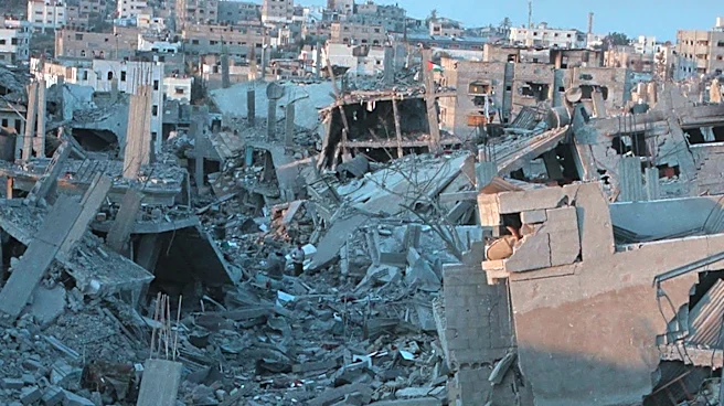
Google Maps has updated its satellite imagery of the Gaza Strip for the first time in over a year, providing a visual record of the extensive devastation caused by the Israeli military offensive. The updated images, primarily from February 2026, show
entire neighborhoods flattened, residential areas reduced to rubble, and dirt tracks cutting through former farmlands and homes. Towns like Beit Hanoun and Jabalia in the north, once agricultural, are now heavily damaged. In the southern Strip, areas like Tel al-Sultan have barely 10 buildings remaining, and the Swedish Village near the Egyptian border has entirely disappeared. Gaza City, which had a population of approximately 650,000 before October 2023, has seen 83% of its buildings damaged by October 2025, according to the UN Satellite Centre (UNOSAT). Central buildings, including those near Omar Mukhtar Street and Palestine Stadium, have vanished, replaced by tents amidst the ruins. The Al-Shifa Hospital, Gaza's largest medical center, is also shown to be practically destroyed after enduring two sieges and bombardments. The Rimal neighborhood, once considered Gaza's most prosperous area, now largely lies in ruins, with several Palestinian government offices destroyed, including the Mushtaha Tower, Gaza's tallest building, which was blown up by the Israeli military in September 2025. The imagery also reveals tents set up by displaced people along the coast at the Port of Gaza.
Why It's Important?
The updated Google Maps imagery provides undeniable visual evidence of the catastrophic scale of destruction in the Gaza Strip, offering a stark and accessible record for the global public. This visual documentation can significantly influence international perceptions and discussions regarding the conflict's impact on civilian infrastructure and human lives. The United Nations estimates that 1.9 million people have been forcibly displaced, 371,888 houses destroyed or damaged (over 60% of the population's homes), and more than half of hospitals are out of service. Nearly all schools have been damaged or destroyed, and Gaza's economy has contracted by 84%, setting back its development by 77 years. This level of destruction highlights a severe humanitarian crisis and poses immense challenges for any future reconstruction efforts. The transparency offered by Google Maps, in contrast to other platforms like Apple Maps, underscores the role of technology in documenting and disseminating information about global conflicts, potentially increasing pressure on international bodies and governments to address the situation. The imagery also serves as a critical tool for organizations involved in damage assessment, humanitarian aid, and post-conflict planning, providing a baseline for understanding the scope of recovery needed.
What's Next?
The widespread destruction documented by Google Maps will likely intensify calls for humanitarian aid and international intervention to address the dire conditions in Gaza. The visual evidence could be used by international organizations and human rights groups to advocate for accountability for the destruction and to push for sustained efforts towards a lasting peace and reconstruction. The scale of the damage suggests that rebuilding Gaza will require a massive, long-term international commitment, far exceeding previous efforts. Discussions around the 'day after' in Gaza will need to contend with the reality of a territory largely in ruins, necessitating comprehensive plans for housing, infrastructure, healthcare, and education. The continued displacement of nearly two million people will also require urgent solutions for shelter and basic services. The updated imagery may also prompt further scrutiny of the conflict by international legal bodies, potentially influencing investigations into alleged violations of international law. The contrast with other mapping services might also encourage other tech companies to provide similar updates, increasing transparency in conflict zones.
Beyond the Headlines
The updated satellite imagery transcends mere documentation; it serves as a powerful testament to the human cost of prolonged conflict and the devastating impact of modern warfare on urban environments. The 'disappearance' of entire villages and the transformation of once-thriving neighborhoods into rubble fields raise profound questions about urban planning, the right to housing, and the long-term psychological and social trauma inflicted upon a population. The imagery also highlights the concept of 'urbicide' – the deliberate destruction of urban life – and its implications for the future viability of Gaza as a habitable place. Furthermore, the role of commercial satellite imagery in conflict zones brings ethical considerations to the forefront, particularly regarding data accessibility, interpretation, and its potential use in legal and political contexts. The 77-year setback in Gaza's development, as estimated by the UN, signifies not just physical destruction but a profound intergenerational impact on education, economic opportunity, and social cohesion, suggesting that recovery will involve not only rebuilding structures but also restoring a sense of normalcy and hope for future generations. The images also underscore the vulnerability of civilian populations in densely populated areas during military operations, prompting deeper discussions on rules of engagement and the protection of non-combatants.