


What's Happening?
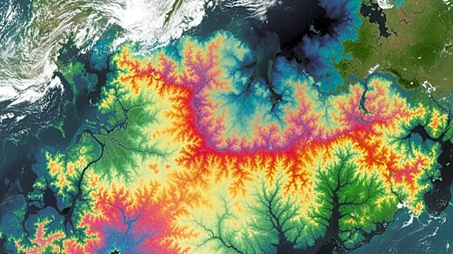
NASA has introduced an innovative online tool that enables users to find their names represented in natural landforms through satellite imagery. This tool, part of the 'Your Name in Landsat' project, utilizes data from the Landsat mission, which has been
capturing high-quality images of Earth's surface for over 50 years. Users can enter their names on the website, and the tool generates images of each letter using natural formations like coastlines, rivers, and mountains. This initiative combines advanced remote sensing technology with an interactive public display, transforming complex Earth observation data into a global art project. The Landsat program, a collaboration between NASA and the USGS since 1972, is renowned for its role in monitoring land use changes and environmental health.
Why It's Important?
The 'Your Name in Landsat' project highlights the potential of satellite technology to engage the public with scientific data in a creative and accessible way. By transforming satellite imagery into personalized art, NASA not only educates the public about Earth observation but also fosters a deeper appreciation for the planet's natural beauty. This initiative underscores the importance of the Landsat program in providing critical data for managing Earth's resources and understanding environmental changes. It also demonstrates how scientific tools can be repurposed to inspire and connect with a broader audience, potentially increasing public interest and support for space and environmental sciences.
What's Next?
As the 'Your Name in Landsat' project gains popularity, it may inspire similar initiatives that use scientific data for public engagement. NASA and other scientific organizations could explore additional ways to make complex data more accessible and engaging. The success of this project could lead to increased public interest in satellite technology and its applications, potentially influencing future funding and support for Earth observation programs. Additionally, the project may encourage educational institutions to incorporate such tools into their curricula, enhancing science education and awareness.
Beyond the Headlines
The project raises interesting questions about the intersection of art and science, and how technology can be used to create new forms of expression. It also highlights the role of public engagement in scientific endeavors, suggesting that making data accessible and relatable can enhance public understanding and support for scientific research. Furthermore, the initiative may prompt discussions about the ethical use of satellite imagery and the balance between public access and privacy concerns.