


What is the story about?
What's Happening?
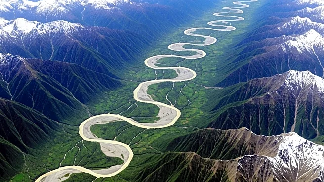
The Yarlung Zangbo River in Tibet, known for its high altitude and deep canyon, is undergoing significant changes in its channels. This braided river, flowing at an average elevation of 4,000 meters, passes through the world's deepest land-based canyon. Recent observations by NASA's Earth Observatory highlight the river's dynamic nature, with channels shifting due to high sediment discharge from nearby mountains. Flooding events frequently remobilize sediment, preventing vegetation from establishing on sandbars. The river's headwaters originate from the Angsi Glacier, flowing across the Tibetan Plateau and through the Indus-Yarlung suture zone, where tectonic plates meet. The river eventually becomes the Brahmaputra River in India, joining the Ganges to form the largest river delta before reaching the Indian Ocean.
Why It's Important?
The Yarlung Zangbo River's dynamic changes have significant implications for the region's agriculture and ecosystems. The sediment deposited by the river creates fertile soil, benefiting local agriculture. Understanding these changes is crucial for managing water resources and predicting flooding events, which can impact local communities and infrastructure. The river's role in connecting different regions highlights its importance in cross-border water management and cooperation. Additionally, the river's geological features provide valuable insights into tectonic activity and climate change impacts, contributing to scientific research and environmental monitoring.
What's Next?
Continued monitoring of the Yarlung Zangbo River by NASA and other scientific organizations will provide further insights into its changing channels and sediment dynamics. This data can inform regional water management strategies and help mitigate the impacts of flooding on local communities. Collaboration between countries sharing the river's resources may be necessary to address cross-border water management challenges. Further research into the river's geological features could enhance understanding of tectonic activity and climate change effects in the region.
Beyond the Headlines
The Yarlung Zangbo River's changes reflect broader environmental and geological processes that can influence regional stability and development. The river's role in sediment transport and deposition highlights the interconnectedness of natural systems and human activities. Understanding these processes can inform sustainable development practices and environmental conservation efforts. The river's unique geological features also offer opportunities for scientific exploration and education, promoting awareness of the region's natural heritage.