




What's Happening?
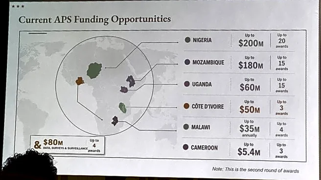
During the AIDS 2026 International Conference in Rio de Janeiro, the U.S. State Department presented an AI-generated map of Africa that incorrectly labeled several countries. The map was part of a presentation on U.S. government commitments to HIV/AIDS
programs, specifically the President's Emergency Plan for AIDS Relief (PEPFAR). The map misidentified the locations of Nigeria, Mozambique, Uganda, Côte d'Ivoire, Malawi, and Cameroon, with some countries placed in entirely incorrect regions. The presentation was attended by high-level officials from the affected countries, who documented and shared the errors online. The State Department has since apologized, attributing the mistake to a last-minute change in the presentation slides.
Why It's Important?
The incident highlights significant concerns about the U.S. government's attention to detail and understanding of African geography, especially in the context of global health diplomacy. PEPFAR is a critical program that has saved millions of lives in sub-Saharan Africa, and any perceived missteps can undermine trust and credibility. The map error comes at a time when the U.S. is attempting to rebuild its reputation in Africa following funding pauses and disruptions under the Trump administration. The viral nature of the map error could exacerbate existing tensions and skepticism about the U.S.'s commitment to its global health initiatives.
What's Next?
The State Department has taken responsibility for the error and is likely to face continued scrutiny over its processes for preparing official presentations. OpenAI, whose tools were reportedly used to generate the map, is investigating how the error occurred. The incident may prompt a review of how AI tools are used in government presentations and the importance of thorough verification processes. African governments and public health advocates may use this incident to push for more reliable and consistent engagement from the U.S. in future health initiatives.