




What's Happening?
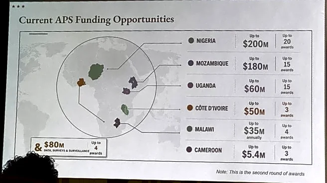
The U.S. Department of State has come under scrutiny after a presentation at the AIDS 2026 conference in Rio de Janeiro featured a map of Africa with incorrect country placements. The map, which was reportedly created using OpenAI tools, showed significant
errors such as Nigeria being depicted as landlocked in the Sahara Desert and Mozambique being relocated to the Horn of Africa. The State Department has acknowledged the mistake, attributing it to a team member's hasty changes to the presentation slides. Despite the error, the department emphasized its commitment to fighting AIDS and maintaining constructive discussions at the conference.
Why It's Important?
The incident highlights the challenges and potential pitfalls of relying on artificial intelligence tools for critical tasks without thorough verification. It underscores the importance of accuracy in international relations, especially when dealing with sensitive topics like health initiatives in Africa. The mislabeling could affect the credibility of the U.S. in international forums and strain diplomatic relations with African nations. Furthermore, it raises questions about the oversight and quality control processes within the State Department, potentially impacting future collaborations and trust with international partners.
What's Next?
The State Department may need to review its internal processes to prevent similar errors in the future, possibly implementing stricter checks on materials used in international presentations. OpenAI's investigation into the use of its tools for creating the map could lead to improvements in AI-generated content accuracy. Additionally, the department might engage in diplomatic efforts to reassure African partners of its commitment to accurate representation and collaboration.