


What's Happening?
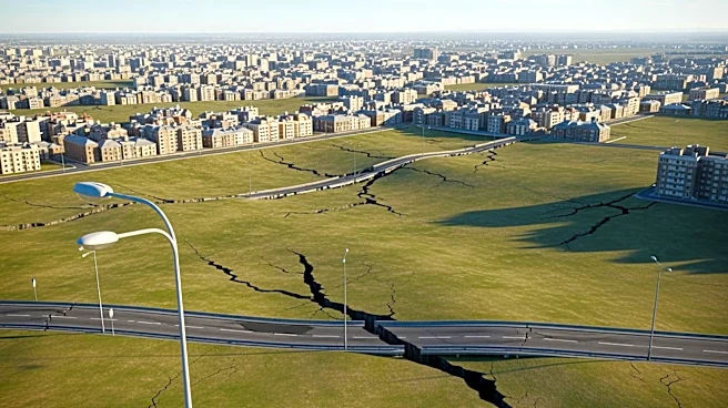
NASA has released satellite imagery from the U.S.-India satellite NISAR, showing that Mexico City is sinking at a rate of more than half an inch per month. This subsidence, which has been occurring for over a century, is primarily due to extensive groundwater
pumping and urban development on the city's ancient lakebed foundation. The sinking has led to significant infrastructure damage, including fractured roads, buildings, and water lines. The new satellite data allows for near real-time tracking of ground movement, providing researchers with unprecedented insights into the city's subsidence patterns. Dora Carreón-Freyre, a researcher with over 25 years of experience studying the phenomenon, highlights the severe impact on areas like Iztapalapa, where many structures are already damaged.
Why It's Important?
The rapid sinking of Mexico City poses significant challenges for its over 20 million residents, affecting infrastructure stability and exacerbating the city's chronic water crisis. The ability to monitor these changes in real-time through satellite technology offers critical data for urban planning and disaster mitigation. This development underscores the urgent need for sustainable water management practices and infrastructure adaptation to prevent further damage. The insights gained from this technology could also be applied to other sinking cities worldwide, providing a valuable tool for addressing similar challenges in coastal and urban areas.
What's Next?
With the new data from NISAR, researchers and city planners can better understand the distribution and rate of subsidence across Mexico City. This information is crucial for developing strategies to mitigate the impact on infrastructure and improve water management. The technology also opens possibilities for monitoring other vulnerable regions globally, where subsidence and sea level rise pose significant threats. Continued collaboration between international space agencies and local governments will be essential in leveraging this data for effective urban planning and environmental protection.
Beyond the Headlines
The sinking of Mexico City highlights broader issues of urbanization and resource management in rapidly growing cities. The reliance on groundwater extraction in many urban areas is unsustainable, leading to long-term environmental and infrastructural consequences. This situation also raises ethical considerations regarding the responsibility of governments and industries to implement sustainable practices and protect vulnerable populations. The advancements in satellite technology provide a powerful tool for addressing these challenges, but they also emphasize the need for proactive policy measures and international cooperation.