





What's Happening?
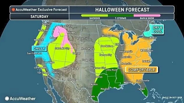
The first week of November is bringing a mix of extreme weather conditions across the United States. A surge of unseasonable warmth is elevating temperatures across the central and eastern U.S., but this warmth is preceding a cold front that will trigger
heavy rain, flash flooding, and severe thunderstorms. Simultaneously, snow is targeting the Rockies. Afternoon temperatures from Texas to Minnesota are expected to be 10 to 20 degrees or more above average, with highs in the 80s in Texas and Louisiana, and 70s reaching as far north as Missouri and Kansas. The Weather Prediction Center has issued an excessive rainfall outlook, indicating a marginal to slight risk (levels one and two out of four) for flash flooding across parts of at least 17 states, affecting almost 48 million people. The Storm Prediction Center also notes a marginal to slight risk (levels one and two out of five) for severe thunderstorms, primarily in the central U.S., with damaging winds and large hail as the most likely hazards, and a few tornadoes not ruled out.
Why It's Important?
This complex weather pattern has significant implications for public safety, travel, and various sectors across the U.S. The combination of unseasonable warmth followed by severe weather increases the risk of rapid changes in conditions, making preparedness challenging. Flash flooding poses a direct threat to communities, infrastructure, and transportation, potentially leading to road closures and property damage. Severe thunderstorms, with their associated risks of damaging winds, hail, and tornadoes, can cause widespread power outages and endanger lives. In the western U.S., mountain snow will impact travel in higher elevations, affecting both residents and industries reliant on clear roadways. The widespread nature of these weather events means that a large portion of the U.S. population will need to remain vigilant and adapt to rapidly changing conditions, impacting daily routines and potentially disrupting economic activities.
What's Next?
The cold front is expected to move from the central into the eastern U.S. during the first few days of the week, pulling the unusual warmth northward and triggering showers and thunderstorms from the southern plains to the northern plains and upper Midwest. The risk of excessive rainfall and flash flooding will be concentrated in the middle of the country, with Florida's Atlantic coast also facing a high probability of flooding due to tropical moisture. In the West, significant snow is anticipated in the central Rockies, with winter storm warnings in effect for areas like southwest Colorado, where 12 to 18 inches of snow are expected above 10,000 feet. Later in the week, a system along the West Coast is projected to bring wintry weather to high elevations of the Pacific Northwest and Intermountain West, along with moderate to heavy rainfall at lower elevations. Residents across these regions should continue to monitor local weather advisories and prepare for potential impacts.
Beyond the Headlines
The simultaneous occurrence of unseasonable warmth, severe thunderstorms, flash flooding, and mountain snow highlights the increasing variability and intensity of weather phenomena. This pattern could be indicative of broader climate shifts, where extreme events become more frequent and widespread. The impact on infrastructure, emergency services, and public health could be substantial, requiring enhanced resilience planning and resource allocation. Furthermore, the disruption to travel and daily life across multiple states could have ripple effects on local economies and supply chains. Understanding these interconnected weather events is crucial for developing comprehensive strategies to mitigate risks and adapt to a changing climate.