


What's Happening?
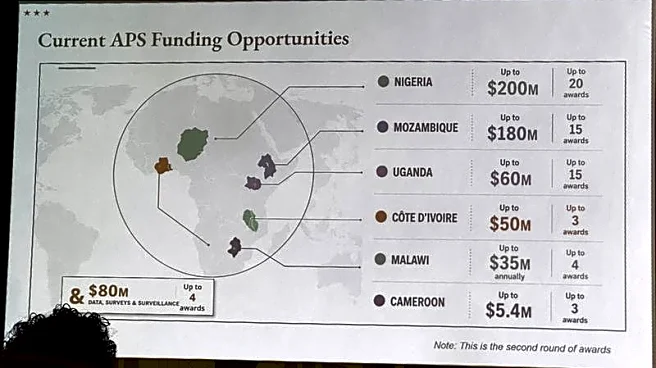
During the AIDS 2026 conference in Rio de Janeiro, the US State Department presented a map of Africa that incorrectly labeled several countries, leading to diplomatic embarrassment. The map, intended to highlight US health assistance and HIV programs,
misidentified six countries: Nigeria, Mozambique, Uganda, Cote d'Ivoire, Malawi, and Cameroon. Nigeria was shown as landlocked, Mozambique was misplaced towards the Horn of Africa, and Cote d'Ivoire was incorrectly positioned. The error was first noted by Emily Bass, an AIDS expert, who described the map as 'completely wrong.' The State Department admitted the mistake, attributing it to a last-minute alteration by a team member. The incident occurred in a session attended by high-level African officials, some from mislabelled countries, causing confusion and misrepresentation.
Why It's Important?
The map error at the AIDS 2026 conference highlights the importance of accurate geographical representation in diplomatic contexts, especially when discussing international health assistance. Such mistakes can undermine the credibility of the presenting institution and strain diplomatic relations with affected countries. The incident underscores the need for meticulous preparation and verification in international presentations, as errors can lead to misunderstandings and potentially impact collaborative efforts in health and other sectors. The State Department's admission of the error and its commitment to taking responsibility is crucial in maintaining trust and cooperation with African partners.