


What's Happening?
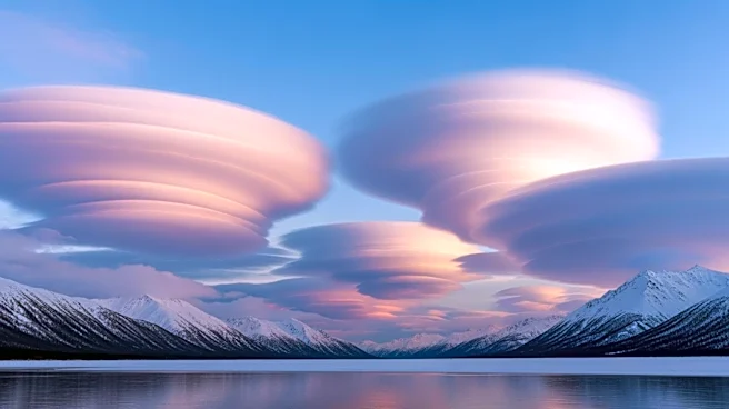
NASA's Terra satellite captured dramatic cloud formations over the Gulf of Alaska on March 19, 2026, marking the end of winter. The image shows cloud streets and von Kármán vortex streets, formed due to atmospheric instability caused by low pressure over the Gulf and high
pressure over eastern Russia and northern Alaska. This setup led to cold Arctic air moving southeast, creating cloud streets as the air mass gained moisture over the warm ocean. The image also features a polar low, a small cyclonic formation with tropical storm-force winds, highlighting the dynamic weather patterns in the region.
Why It's Important?
These cloud formations provide valuable insights into atmospheric processes and weather patterns in the Arctic region. Understanding these phenomena is crucial for improving weather forecasting and climate models, particularly as climate change continues to impact polar regions. The data can help scientists predict future weather events and their potential impacts on local communities and ecosystems. Additionally, the study of such atmospheric phenomena contributes to broader climate research, aiding in the development of strategies to mitigate the effects of climate change.
What's Next?
As the weather in Alaska transitions from winter to spring, scientists will continue to monitor atmospheric conditions and cloud formations. This ongoing research will contribute to a better understanding of seasonal weather patterns and their implications for climate change. The data collected will also support efforts to improve weather prediction models, which are essential for preparing for and responding to extreme weather events.