


What's Happening?
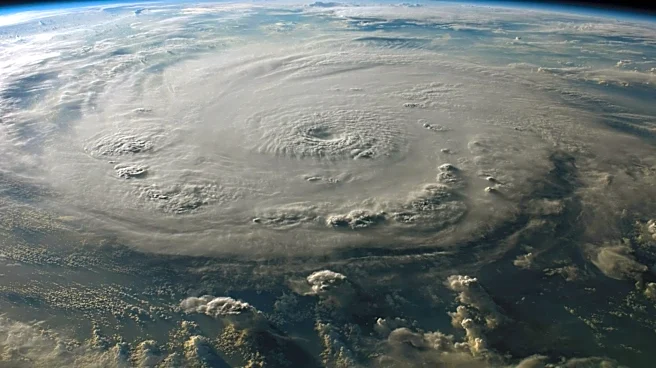
Typhoon Jangmi, a slow-moving storm, has been affecting the Philippine Sea and southern Japan with torrential rainfall since late May 2026. The storm, classified as a category 1 typhoon, has sustained winds of 120 kilometers per hour. Satellite imagery
captured by NASA's VIIRS shows detailed views of the storm's eyewall and eye, along with mesocyclone features. Jangmi's outer cloud bands have reached over land, raising concerns about flooding in several regions. Forecasts predict the storm will approach Okinawa and move northeast, continuing to deliver heavy rain along Japan's Pacific coast.
Why It's Important?
Typhoon Jangmi's impact on southern Japan highlights the challenges posed by severe weather events in densely populated areas. The heavy rainfall and potential flooding can disrupt daily life, affect infrastructure, and pose risks to public safety. Accurate satellite monitoring is essential for timely warnings and disaster preparedness, helping mitigate the storm's effects. The data collected by NASA's VIIRS contributes to understanding storm dynamics and improving forecasting models, which are crucial for emergency response and planning.
What's Next?
As Typhoon Jangmi progresses, authorities in Japan will likely continue to issue warnings and advisories to ensure public safety. Emergency services may be mobilized to address flooding and other storm-related impacts. The storm's movement will be closely monitored to predict its path and potential intensification. Long-term, the data from this event will be analyzed to enhance storm prediction capabilities and inform future disaster preparedness strategies.