


What's Happening?
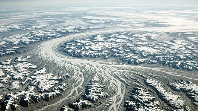
An astronaut aboard the International Space Station captured a striking image of the James Bay Lowlands in late March 2026, highlighting the region's glacial history. The photograph shows frozen channels feeding Hannah Bay, a southern extension of James Bay, which
is part of Hudson Bay. This area was once covered by the Laurentide Ice Sheet during the Pleistocene Epoch, which depressed the land under its immense weight. Since the Last Glacial Maximum about 20,000 years ago, the ice has retreated, and the land has been experiencing glacial isostatic adjustment, rising approximately 10 millimeters per year. The image reveals faint, closely spaced ridges formed by tidal action along the shore, as well as boreal peat bogs that store significant amounts of soil carbon.
Why It's Important?
The photograph and the ongoing study of the James Bay Lowlands provide valuable insights into the Earth's glacial history and current geological processes. Understanding glacial isostatic adjustment is crucial for predicting future changes in sea levels and land elevation, which have significant implications for climate change research. The peatlands in the region are also important carbon sinks, playing a critical role in global carbon cycles. This research can inform environmental policies and conservation efforts aimed at mitigating climate change impacts.
What's Next?
As the seasons change, the James Bay Lowlands will transition from a frozen landscape to a lush, green environment. This seasonal transformation will be closely monitored by scientists to study the effects of climate change on the region's ecosystems. The ongoing research will continue to provide data that can be used to model future environmental changes and guide policy decisions. Additionally, the images captured by the International Space Station will be made available to the public and scientific community, fostering further research and education.