


What's Happening?
Woolpert and Saildrone have teamed up to conduct bathymetric surveys for the National Oceanic and Atmospheric Administration (NOAA) in the Mariana Islands. This collaboration aims to support NOAA's initiatives for safe navigation and national ocean mapping,
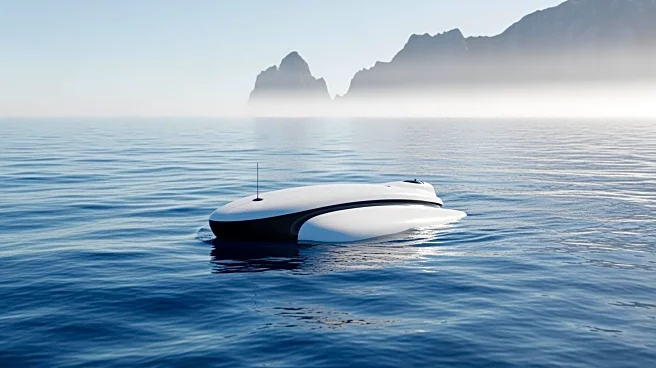
including the National Strategy for Mapping, Exploring, and Characterizing the United States Exclusive Economic Zone and the Seabed 2030 initiative. The project involves the use of a 20-meter Saildrone Surveyor, an uncrewed surface vehicle designed for deep-ocean mapping and maritime intelligence. The Surveyor, powered by a combination of a high-efficiency diesel engine and wind energy, is capable of operating autonomously for extended periods, collecting high-resolution bathymetric data in challenging environments. This data will be transmitted to Woolpert for processing and will help close critical bathymetric gaps in the U.S. exclusive economic zone, enhancing NOAA's understanding of marine ecosystems and geohazards.
Why It's Important?
The partnership between Woolpert, Saildrone, and NOAA is significant as it leverages advanced autonomous technology to improve ocean mapping capabilities. This initiative is crucial for enhancing maritime safety, understanding marine ecosystems, and managing ocean resources effectively. By closing bathymetric gaps, the project supports the U.S. in maintaining its strategic interests in the Pacific region, particularly around the Mariana Islands. The data collected will aid in ecosystem management and expand taxonomic reference libraries for marine organisms, contributing to scientific research and environmental conservation efforts. Additionally, the use of uncrewed systems represents a shift towards more efficient and cost-effective methods of conducting oceanographic research.
What's Next?
The contract for this project is currently underway and is expected to conclude in May 2026. As the data collection progresses, NOAA will likely analyze the findings to enhance its oceanographic models and resource management strategies. The success of this project could lead to further collaborations and the adoption of similar technologies in other regions. Stakeholders, including environmental agencies and maritime industries, may respond by integrating these insights into policy-making and operational planning. The project's outcomes could also influence future investments in autonomous maritime technologies, promoting innovation in ocean exploration.
Beyond the Headlines
This collaboration highlights the growing importance of autonomous technologies in scientific research and environmental monitoring. The ability to conduct long-duration, high-resolution surveys without human intervention reduces risks and costs associated with traditional methods. It also underscores the strategic importance of the Mariana Islands, not only for their ecological value but also for their geopolitical significance. As nations increasingly focus on maritime security and resource management, projects like this could play a pivotal role in shaping international maritime policies and cooperation.