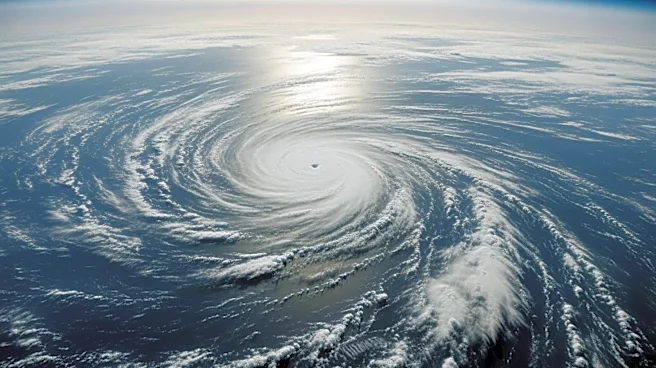


What's Happening?
In April 2026, Super Typhoon Sinlaku, a severe storm in the Pacific Ocean, generated atmospheric gravity waves that were detected by satellites. These waves, visible as concentric rings, reached the mesosphere, indicating the storm's intensity and impact
on the atmosphere. The phenomenon was captured by the VIIRS instrument aboard the NOAA-20 satellite, revealing the storm's influence on atmospheric layers and providing insights into the dynamics of tropical cyclones.
Why It's Important?
The detection of atmospheric gravity waves from Super Typhoon Sinlaku offers valuable data for understanding the interactions between severe weather events and atmospheric dynamics. This information is crucial for improving weather forecasting models, particularly for predicting storm intensification over oceans. The study of these waves also has implications for understanding long-term weather patterns and their effects on global climate systems, potentially aiding in the development of strategies to mitigate the impacts of severe weather.
What's Next?
Researchers aim to use the data from Sinlaku to refine models of atmospheric gravity waves and their role in storm dynamics. Further studies may focus on the impact of these waves on the ionosphere and their potential to disrupt satellite communications. Continued satellite monitoring and analysis of future storms will enhance our understanding of atmospheric processes and improve predictive capabilities for severe weather events.