Almost every corner of Sedona, Arizona could be a postcard-worthy photograph. It's a destination renowned for its glowing red rock canyons along with some of the most romantic views in the Southwest. All
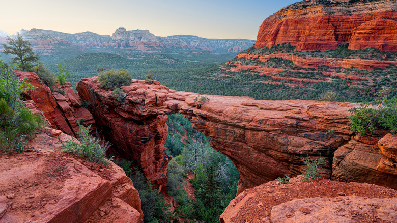
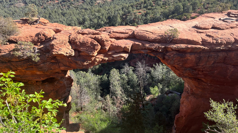
through these canyons are hundreds of miles of walking and hiking routes. Another Sedona hike that's near the top of the list in terms of photogenic reward is the Devil's Bridge Trail, which ends in front of a sprawling red sandstone arch. This happens to be the largest arch in the Sedona area and one of the most photographed places in the entire state. Visitors can even dare to walk across it if they're feeling audacious.
The length of the hike varies depending on what kind of vehicle you have and where you park your vehicle along Dry Creek Road. Standard vehicles should be parked at the lot at the Dry Creek Vista Trailhead, which is just a 15-minute drive from the regional Sedona Airport or about two hours from the Phoenix Sky Harbor International Airport. From here, the round-trip hike to the arch is 4.2 miles.
The Devil's Bridge Trailhead is actually a little further past this parking lot as you continue along Dry Creek Road. But to drive all the way to this trailhead, you'll need a high-clearance, four-wheel drive vehicle, as this portion of the road is very rough. If you have an appropriate vehicle, you can park right at the Devil's Bridge Trailhead. From there, the hike to the arch is only a 2-mile round trip. The trail has a gradual incline and becomes narrower and steeper after about a half mile, with some rocky steps and scrambling involved. Once you approach the arch, the trail forks, and you can either go to the flat viewing area below the bridge or proceed across the top of it. If you decide to brave the walk on top, you'll get views of the expansive canyon and its layered, richly colored sandstone.
Read more: The 5 Best Hidden Hot Spring Hikes In California
Helpful Tips For Hiking To The Arch
The Devil's Bridge Trail can be super crowded, especially on weekends and during holidays, so your best bet is to go midweek or during the off-season (winter). You can also avoid the crowds around the parking lot at the Dry Creek Vista Trailhead and along Dry Creek Road by hiking an alternative trail. One option is the Mescal Trail, which starts on Long Canyon Road and goes for about a mile before reaching the Devil's Bridge Trailhead. Yet another option is the Chuckwagon Trail, which starts at the same area as the Dry Creek Vista Trailhead but veers away from Dry Creek Road, winding through gorgeous desert scenery and forest. This is a longer hike, but you'll get much better views and encounter fewer people. However, no matter which route you take, expect there to be a wait for photo ops once you get to the arch.
It might be tough to find parking at the Dry Creek Vista Trailhead parking lot unless you arrive very early in the morning (by 7 a.m.). The later you arrive, the further away from the trailhead you'll have to park as spots fill up. One way to bypass parking concerns is to take the free Sedona Shuttle. The shuttle is available from Thursday to Sunday, departing every 15 to 30 minutes from the Posse Grounds Park and Ride lot and taking you right to the Dry Creek Vista Trailhead (among other trailheads). While you're in Sedona, be sure to check out other remarkable hiking trails, like the one to the otherworldly Bell Rock, a famous landmark that draws vortex seekers from around the world, as well as the Broken Arrow Trail, a popular, accessible, and beautiful route that also provides some challenges and thrills.
Ready to discover more hidden gems and expert travel tips? Subscribe to our free newsletter for access to the world's best-kept travel secrets.
Read the original article on Islands.