The United States is one of the greatest places in the world for outdoor exploration. Whether you're in search of epic alpine opportunities, remote desert treks, or even just a pleasant walk in your city,
there's something for you. Even for those who don't love hitting the trails, Grand Teton National Park has them covered as the best national park for people who hate hiking. And statistics show appreciation for the great outdoors is growing, with the number of Americans hiking doubling in the last decade. That's great news, but it brings with it some negatives — not least busy trails.
With all that growth, the AllTrails app has become an indispensable tool in over 80 million hikers' phones. But its new premium update is taking things to an entirely different level, offering high-tech tips for hikers to discover and create new routes, check conditions in real time, and even see how busy it could be. Using all the new data, AllTrails revealed the busiest trails in America, and its new update might just make it easier to avoid them, too.
Avalanche Lake, in Montana, topped the list, with Delicate Arch, Utah; Devil's Bridge, Arizona; Skyline Loop, Washington; and Navajo Loop and Garden Trail, Utah, completing the top five in that order. Each of them is spectacular and deserves all the love they receive, but it might be worth taking a look at AllTrails to help beat the crowds.
Read more: The 5 Best Hidden Hot Spring Hikes In California
What's In The New AllTrails Update?

In the past, AllTrails centered around community. While that's still the case, its new Peak Membership — a premium tier costing $79.99 a year — offers radical new tech-centered features allowing users to customize like never before and delve into epic amounts of data to help prepare for a hike. A combination of two of these features can be used to help avoid heavily trafficked trails and even create better alternatives in the same area.
Its custom routes feature puts users in complete control of their hikes, with the option to start from scratch, building a route based around points of interest like peaks, waterfalls, or viewpoints, or edit an existing trail to match their preferences. It even uses smart one-tap features that edit routes according to specific parameters like steepness, length, or even how scenic it is. The community heatmap is another new feature, using a slick interface to highlight the most used trails in any given region. To see it in action, check AllTrails' route for the Salkantay Trail to Machu Picchu, an uncrowded alternative to the Inca Trail in Peru. The Inca Trail is a darker purple color, highlighting more people on the trail. This feature, along with reviews and logged hikes, is how AllTrails built its list of the most popular trails.
Before heading out on a hike in the same vicinity as the most popular routes, it's worth checking out the heatmap. If there's only one trail, your hands are tied, but if there are multiple options, you can use the custom routes feature to avoid the most heavily trafficked parts, helping your hike become the peaceful experience you wanted it to be. It's also added a trail conditions feature that'll help with planning for weather, bugs, and even air quality.
How To Use AllTrails To Avoid Avalanche Lake, The Busiest Trail In America
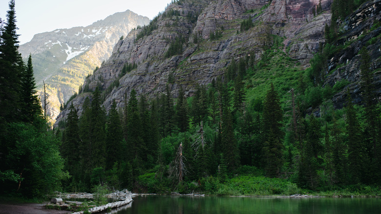
The breathtaking Avalanche Lake Trail in Montana is the busiest trail in the country for a reason. Tracing the edge of the eponymous lake, the almost 6-mile trail is stunning. From the clear blue glacial waters to the relative ease of the trail, it's the perfect introduction to Glacier National Park. But with over 37,500 hikes logged on the trail, finding some alone time might be tough. Plenty of reviews on the app complain about the crowds being out of control, with parking sometimes adding over half a mile to the trail.
A quick look at the Avalanche Lake area in the AllTrails App with a Peak membership backs this up. There are deep purple lines running the entire length of the out-and-back trail. Worse, it's a narrow valley, so other trails are limited if you want to stick to this specific lake. But if you move to the far end, you'll find a lower density of hikers making the short climb towards Monument Falls. If you can grin and bear the crowds to the end of the lake, you could reward yourself with a quieter hike up to the falls.
Other than that, you'll need to look elsewhere in the park to find some solace. Remember, easy trails are always going to be the busiest as they attract the largest diversity of people. More experienced hikers or climbers can look at other options that a novice may not even attempt.
How To Use AllTrails To Avoid Delicate Arch, The Second Busiest Trail In America
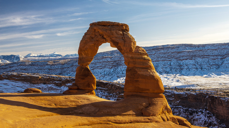
Delicate Arch trail is an immensely popular trail, owing to its iconic red sandstone arch that balances precariously on the edge of a cliff. It's a popular symbol of the state, even featuring on Utah license plates, and had the 2002 Winter Olympics torch pass through on its procession. It's a short 3.2-mile out-and-back route, and with over 31,000 activities logged on its AllTrails page, you can expect it to be busy. Of course, this is to be expected when the trail revolves around an iconic landmark.
Once again, the popularity is backed up by the community heatmap, with both the close-up and further away viewpoints showing high levels of foot traffic. One thing that's especially noticeable here is the number of hikers veering off the traditional path. There is a viewpoint across from the arch that isn't listed, which is far less frequented. While this may seem like a hack, it's imperative to stick to paths where possible and avoid any damage to the rocks and plants. Some parks allow off-trail hikes, while others prohibit them strictly.
Pulling the map out slightly, you'll find a number of other hikes and climbs with varying degrees of popularity. If you're looking for something super quiet and have some canyoneering ability, trails around Owl Rock and the Garden of Eden are far less busy. Again, dotted all over the park are many off-trail routes, too. You could always avoid Arches National Park crowds completely by hiking the nearby Fisher Tower Trail
How To Use AllTrails To Avoid Devil's Bridge, The Third Busiest Trail In America
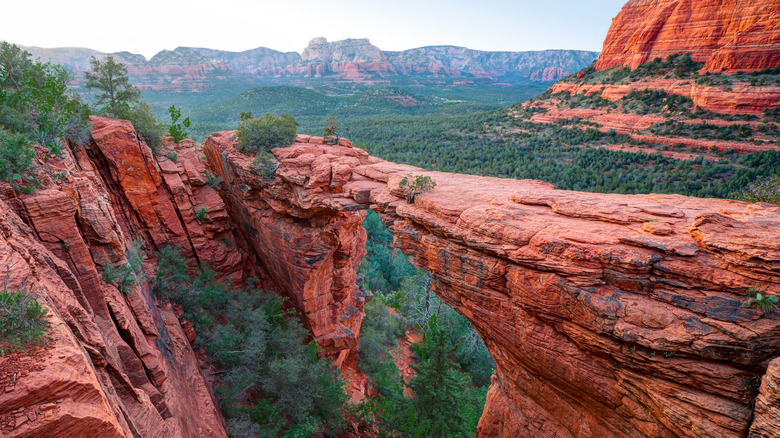
The beautiful Devil's Bridge Trail is another hike centered around sandstone arches — hikers love 'em. Set in the underrated desert oasis of the Sedona Wetlands Preserve, the main trail via Mescal Road is a 3.9-mile out-and-back route. It's only listed as a moderate difficulty level and features 528 feet of elevation gain. Its proximity to hiker-heavy Sedona is a likely factor in the overcrowded patterns on the trail.
While AllTrails heatmap function shows high traffic along the main route, there are multiple paths jutting off towards the end that show far lighter crowds, offering the chance to find a little more calm amongst the chaos. It also highlights an immense 15-mile route that loops all the way from Sedona itself. While still a popular route that finishes in the same place, the majority of the trail is far quieter — just be prepared for a longer slog.
The AllTrails app also allows users to compare heatmap data between the most recent month and the past year. Its default is 12 months, but it's possible to reduce that to just the last 30 days. This can be helpful at different times of the year, as the paths may be drastically quieter or busier depending on the seasons. Make sure to flip between the two to see the trends.
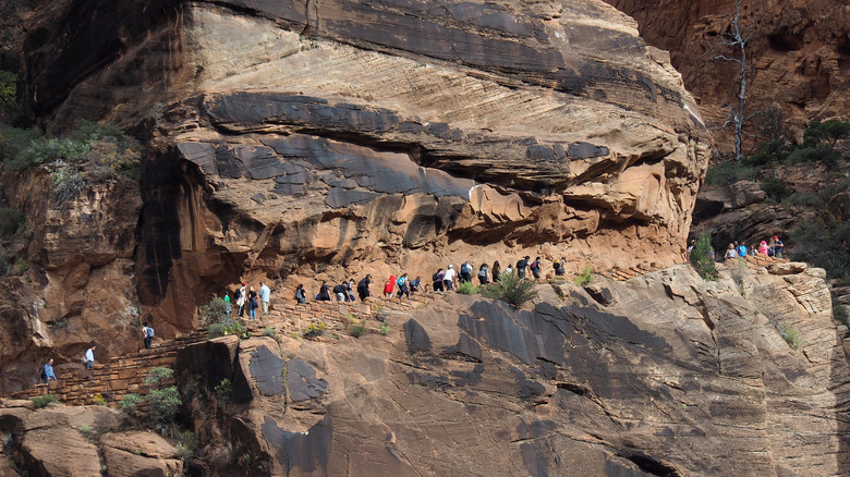
How To Use AllTrails To Avoid Skyline Loop And Navajo Loop, The Third And Fourth Busiest Trails In America
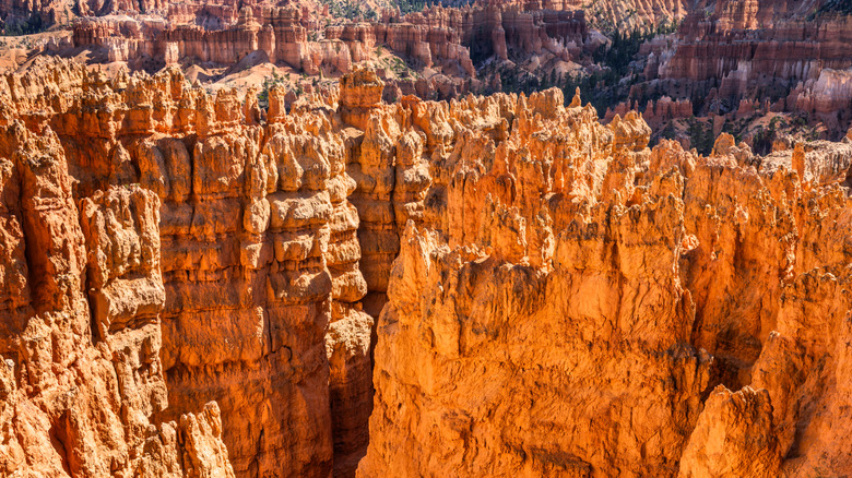
Rounding out the top five busiest trails in the US are Skyline Loop in Washington and the Navajo Loop and Queens Garden Trail in Utah. Skyline is a scenic circular route around Mount Rainier — the major West Coast volcano that could be about to erupt — while the Navajo Loop functions as a highlight trail of the most unique rock formations in Bryce Canyon National Park. Both are strong examples of how helpful the new AllTrails update can be.
The Skyline Loop map is the perfect demonstration, arguably the best of the five, as to how you can hike in the same area but avoid the crowds. While the others are all in-and-out trails with minimal deviation from a set path, there are multiple trails crisscrossing around the park. Building your own route using the lighter colored paths would be simple here.
On the Navajo Trail, it's easy to see where things are going to get super busy. With so many iconic viewpoints on one trail, the heat map lights up in huge bunches where crowds are gathering for photos. Adding the photo overlay to the map can let you find some lesser-used photo spots to get the best from your own hike without having to wait half an hour for a look at the coolest formations.
Ready to discover more hidden gems and expert travel tips? Subscribe to our free newsletter for access to the world's best-kept travel secrets.
Read the original article on Islands.