Following the winding Colorado River through Utah's wondrous red rock canyons from the city of Moab to its endpoint at Canyonlands -- the Utah National Park that has some of the Southwest's most vibrant
canyon views -- is the 17-mile scenic byway known as Potash Road. Also known as the Lower Colorado Scenic Byway and or Utah State Route 279, this scenic route packs in ancient petroglyphs, rock climbing areas, and breathtaking sandstone arches into every mile.
To access Potash Road, you'll need to travel to the Utah city of Moab, which is a relatively straightforward process. While heading there, though, you might also want to check out this itinerary for a scenic, unforgettable road trip to Utah's five national parks. Moab is easily accessed via Interstate 70 and U.S. Highway 191 from the east or west, or U.S. 191 from the south. With gear outfitters and trail-rated vehicle rentals plentiful in an adventure town like Moab, flying in won't limit your adventure.
Canyonlands Field Airport (CNY) is just over 18 miles north of Moab, offering flights with select airlines from only a few destinations. For others, Salt Lake City International Airport is the nearest major airport at around 238 miles away. Experience the best the town has to offer before setting out on Potash Road. Fuel up at espresso bars, like the trendsetting Moab Garage Co. or Moab Coffee Roasters, or end a day of adventure with live blues music, diners, and food trucks in the "Adventure Capital of the West."
Read more: The 5 Best Parks Where You Can See Bison Roam (Other Than Yellowstone), According To Visitors
Wall Street On Potash Road Offers Petroglyphs And Sandstone Canyon Scenery

From Moab, U.S. Highway 191 North leads to Utah State Route 279 (Potash Road), with a left near the entrance to Arches National Park. This stretch of Potash Road will begin to hug the nearby Colorado River as it heads through the canyons to one of the first iconic landmarks of the byway. Wall Street is a section about 3 miles from the U.S. 191 entrance, named for its iconic rock climbing, with over 140 routes in total, with difficulties from 5.3 to 5.12.
The towering vertical red sandstone cliffs butt right up against the road, creating a visually striking scene. Just a heads-up on this stretch of Potash Road: It gets congested, so drive carefully and be mindful of cyclists and pedestrian climbers scouting their routes. A bit further down the byway, around 5 miles into the 17-mile trek, there are two pull-offs labeled "Petroglyphs" and "Indian Writing."
Carvings depicting humans, animals, and mysterious symbols can be seen from the pullouts right along the road and are estimated to date back to the Archaic and Fremont periods. Continue along Potash Road to mile 7 for another ancient mystery at the Poison Spider Trailhead. Follow a sign marked "dinosaur tracks" from a split in the trail to visible dinosaur tracks and more petroglyphs, hike 2.3 miles to the Longbow Arch, or take on the mountain biking trails along the top of the mesa.
Potash Road Arches, Hiking Trails, And Off-Road Adventure
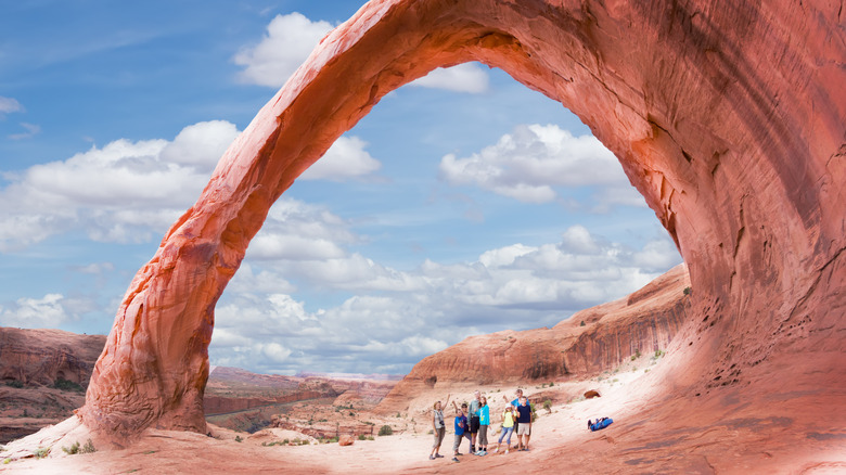
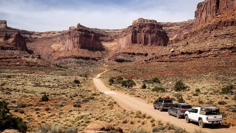
From the Poison Spider Trail, it's on to Potash Road's legendary arches and trails. At mile 10, stop at the Corona Arch Trailhead for three arches in one hike. The trail is a 2.3-mile, moderately challenging, out-and-back route located near the Gold Bar camping area, crossing slickrock benches and a scrambling area with a ladder and safety cable. The trail also heads to Bowtie Arch, with the Pinto Arch visible in the distance and reachable via a separate fork of the trail.
At just over 13 miles in, you'll find Jug Handle Arch and the entrance to Long Canyon Trail. Jug Handle Arch is viewable from the byway and parking area, but a short hike up leads to some petroglyphs and a closer look at the arch. Long Canyon Trail is a popular mountain biking and hiking trail, as well as a scenic OHV trail and shortcut to Canyonlands and Dead Horse Point State Park for trail-equipped vehicles.
When the pavement ends, you'll arrive at Potash Boat Ramp, where a different adventure begins, heading into Utah's canyon with world-famous rapids that offer a popular and wildly thrilling whitewater experience. Book a rock climbing or canyoneering introduction along the Wall Street section of Potash Road or a Cataract Canyon rafting adventure to extend your Potash Road excursion. Though the pavement ends, Potash Road continues as the 4x4 Shafer Trail, heading into Canyonlands National Park, yet another opportunity for a Utah adventure.
Ready to discover more hidden gems and expert travel tips? Subscribe to our free newsletter for access to the world's best-kept travel secrets.
Read the original article on Islands.